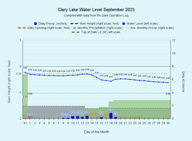
I have archived the September 2023 water level chart (above, and at left). The rain we’ve come to expect this Summer just didn’t materialize last month with only 2.80 inches of rain falling (73% of normal) or a full inch less than the 3.84 inches we would normally receive in September. An obvious impact has been the gradual drop in water level. That said, who didn’t like the extended stretch of warm dry weather in September? Of the first 9 months of 2023, only 3 months had less than the normal amount of precipitation: September (73% of normal), March (67% or normal) and February (52% of normal). The month with the highest precipitation was July, with 8.2 inches (232% of normal) followed closely by January with 7.19 inches (225% of normal). Despite shortfalls in those three months, at the end of September we were still 12.65″ ahead of normal. To better grasp how big a differential that is consider that our average annual rainfall is 44.06 inches, and we’re already there- we’ve already received more than that. Even if we were to receive NO MORE rain or snow for the REST OF THE YEAR, we’d still end up a hair above normal annual rainfall. That is how far above normal precipitation we are this year. The overall precipitation statistics for 2023 are impressive. You’ll find all kinds of data and charts on the Precipitation sheet of our Clary Lake Dam Operation Log.
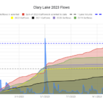
 The most notable thing about this year so far is the sheer volume of water that has passed through Clary Lake and downstream to the Sheepscot River. The chart at left shows the outflows from Clary Lake in acre-feet for each of the last 5 years (an acre-foot of water is one acre of water one foot deep; think a square 208.7′ x 208.7 x 1 foot). You can see that by the end of April outflows were already higher than average, and then we received 5.5 inches of rain on May 1st. That jumped the outflows a lot, and there was no looking back. The two horizontal dashed lines represent lake volumes (Clary Lake contains 7224 acre-feet of water) and you can see here that at the end of September, we’re close to two full lake volumes of water having passed out of Clary Lake, considerably more than in any of the past 5
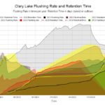
  years, and there are still 3 months to go. I have no doubt we’ll end the year with a record flushing rate. Flushing rate and retention time are actually annual statistics so we can’t meaningfully calculate them now, but we can observe the accumulation of data over time and learn from it. The chart at left shows flushing rates and retention times for the past 5 years using the same colors as the above chart of 2023 flows. The lines in the charts “look” the same even though they represent different statistics because they’re all based on total outflows
What does all this flow data tell us? Well, along with other data we collect, it helps us understand what’s going on with our lake. Clearly, the conditions which affect our lake water quality vary from year to year. Our rainfall varies, and the nature of that rainfall varies- did we have a few heavy storms with lots of runoff or many small rain events with little to no runoff? Runoff introduces sediment and phosphorus. Insolation (sunlight) varies, which affect water temperature. We had a lot of clouds this summer (duh!) and smoke from Canadian wildfires with the result that insolation was down and the highest water temperature we recorded was only 79.3° on July 23rd. For comparison, we recorded 82.0° on August 5th, 2022 (the highest water temperature we’ve recorded was 84.2° was in August 2019). That’s a big difference! Water temperature (among other things) affects dissolved oxygen and algae growth. There’s a lot to take into account, and our goal is to understand as best we can how our weather and other factors affects our lake and its water quality. This is the challenge.
Last summer we were in severe drought with very little water entering OR leaving Clary Lake and we ended up suffering the worst algal bloom anyone can remember. The flows associated with the summer of 2022 are represented by the yellow solid line and the line is almost flat while the retention time line (dotted) shows that water hung around in Clary Lake a long time before finding its way to the outlet. Contrast 2022 with this year when we’ve experienced the complete opposite of drought: a steadily rising red line representing heavy outflows all summer and a record low retention line indicating water that entered Clary Lake didn’t hang around very long.
This years flows have undoubtedly contributed to our generally good water quality this summer, but fall turnover, as expected, has resulted in the appearance of a mild algal bloom. You can read about it here: Blue-Green Algae Finally Makes an Appearance.
What’s the next month going to bring?


Great article George.
Very interesting and informative.
Thanks Dave, I try. I was worried this post was getting too long, so I kinda wrapped it up quickly.