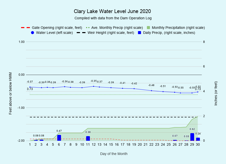
I have archived the June 2020 Water Level Chart (at left). For the second month in a row, the most notable thing about the chart is how relatively stable the water level was especially in light of how little rain we received! Total water level variation for the month was only 0.18 feet (2.2 inches), starting out the month at -0.37 feet below the HWM, falling to a low of -0.55 feet on the 27th, and finally ending the month a little higher at -0.50 feet below the HWM thanks to some much needed rain. Keep in mind that the HWM is actually 3 inches or so ABOVE the lowest point on the dam; for most of the month the lake was pretty much lapping at the top of the dam. We really can’t get more stable than that.
Total rainfall for June was only 1.97 inches, well short of the average for the month of 3.73 inches. We actually went without any rain at all for 14 days, from the 12th until the 25th. For the year we’re at 20.37 inches which is only slightly below the average for this date of 20.88 inches, thanks primarily to the excessive rain we received in April. The lack of rain has resulted in Moderate Drought conditions in Central Maine, which condition has only been slightly mitigated by the 0.95 inches of rainfall we received at the end of the month. If this trend continues things are going to get real dry this summer. The general consensus of the scientific community is that the effect of climate change on Maine weather is for us to have warmer and wetter winters and warmer and DRIER summers. Certainly our experience over the last 5 years corroborates that consensus.
Water quality (as opposed to quantity) is very good so far this summer. On June 21st we had a secchi disk reading of 3.95 meters and a surface water temperature of 80.4° F. Transparency tends to remain relatively high during summers when we experience low rainfall amounts due to the lack of runoff.

