 Kelley finally closed the dam’s gate which has been wide open since last October 13th. Must have been done sometime today though I suppose it could have been late yesterday afternoon. I’m not sure what inspired this seemingly magnanimous gesture on Kelley’s part: concern over the drained wetlands? Not likely. Worry for lost wildlife habitat? Nah. Sadness over the unusable status of the State boat launch? Nope. You can be sure whatever reasons motivated him they were selfish and self-serving. He’ll get no thanks from me. The lake is down 56″ below the top of the dam and the crime has been committed. I suppose we should be grateful that Kelley has closed the gate but I’m still angry with him for draining the lake in the first place. Call me ungrateful but in my book it’s too little, too late.
Category Archives: Lake Environment
15 May 2013: Clary Lake Water Monitoring Data Now Online
 We’ve finally gotten around to putting current Clary Lake water monitoring data online. It’s a subset of the data collected by David Hodsdon and Jack Holland and will be updated roughly every 2 weeks from early spring through late fall or as often as David and Jack get around to it. What’s online now includes all the data from 2012 and what’s been collected so far in 2013. That little thumbnail at left is what a secchi disk looks like- it’s used to measure the transparency of the water.
I hope to get some historical data online soon; there’s quite a bit of it. David has been collecting water quality data on Clary Lake since 1975, Jack Holland since about 2001. Both are certified volunteer water quality monitors. Here’s a typical data sheet from a data collection session and here are 3 charts based on the collected data. Graphing the data is helpful because it allows you to see trends in the data that aren’t necessarily obvious from just looking at it. One disturbing trend evident from the secchi disk chart is that the transparency of the lake water has deteriorated markedly in recent years. This trend also coincides with the increase in phosphorus evident from the Total Phosphorus chart. We’ll be talking more about these trends in the near future.


Last spring I accompanied David and Jack on one of their regular water quality monitoring sessions and have put together a short photo gallery of that session: “Our Water Quality Monitors at Work“.
13 May 2013: How Low Can It Go?
Some of you will remember seeing a table something like this last year, on the old site:
| Inches Below Top of Dam | Rate of Fall in 24 Hours |
| 0″ to 36″ | 1″ |
| 36″ to 48″ | 3/4″ |
| 48″ to 62″ | 1/2″ |
| Below 62″ | 1/4″ or less |
These figures were derived empirically which simply means these are based on measurements we made and recorded. They are what they are. They’re averages and on any given day they will likely vary a little or (even a lot) due to changing conditions: lake surface area, the shape of the lake, and most important, the amount of runoff from rain or snow melt. But all things being equal, these numbers should be pretty close most of the time.
Which brings me to the reason for this post: the question of how low can the lake get. I have in the past come to the conclusion that the rock-bottom low water level was 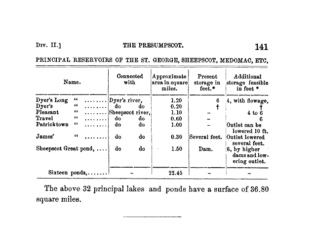 somewhere around 6 feet (-72″) below the top of the dam. This figure was arrived at after measuring the water depth at the mouth of the channel at the northwest end of the lake. I also came across a fascinating book entitled “The Water Power of Maine” by Walter Wells, first published in 1869. In it I found a table that I’ve reproduced the table at left. It estimates the additional storage in Pleasant Pond (now Clary Lake) as 4 to 6 feet. Coincidence? I don’t think so.
Yesterday afternoon Colin Caissie and I went over to look a the narrow gauge rail road abutments to assess their suitability for the construction of a coffer dam. To get the 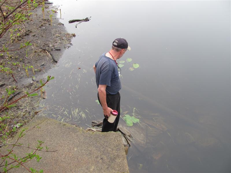 distance between the abutments, I waded across the channel (and filled my boots in the process) while dragging a tape measure and found the center of the channel to be 2′ deep. The water level at the time was -54″ below the top of the dam. Adding 24″ to this gives you an elevation of the center of the channel between the abutments of -78″ or -6.5 feet below the top of the dam. The average distance between the abutments by the way is 16.5′. There are more pictures from this adventure in the Spring 2013 gallery.
And there you have it folks. The lake can’t possibly fall more than 6.5′ below the top of the dam and chances are, since there is a gentle slope to the channel on the order of about 1/2 a foot over it’s entire length, the limiting factor likely is the elevation at the entrance of the channel. So if anyone asks you how far the lake can fall, tell `em “6 feet.”
The lake is down -54″ now. It can fall another 18″. Last spring it reached -63″ below the top of the dam. At the rate the lake is dropping, we’ll get there again in 10 days.
06 May 2013: A Year and a Half of Water Level Records
I got to wondering what a water level chart showing all the water level data I have collected since the 19th of December 2011 to today would look. The result isn’t pretty:
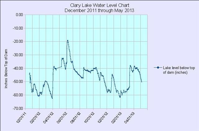
With the exception of May and June of last year and a few days in March and early April this year, the lake has been lower than -40″ below the top of the dam since I started keeping records. It will take a long time for the wetlands to recover from being “ravaged” to use a term Mr. Kelley seems to like so much.
I’ll update this graph periodically. I haven’t decided where it will live.
28 April 2013 Commentary: Spring is finally here.
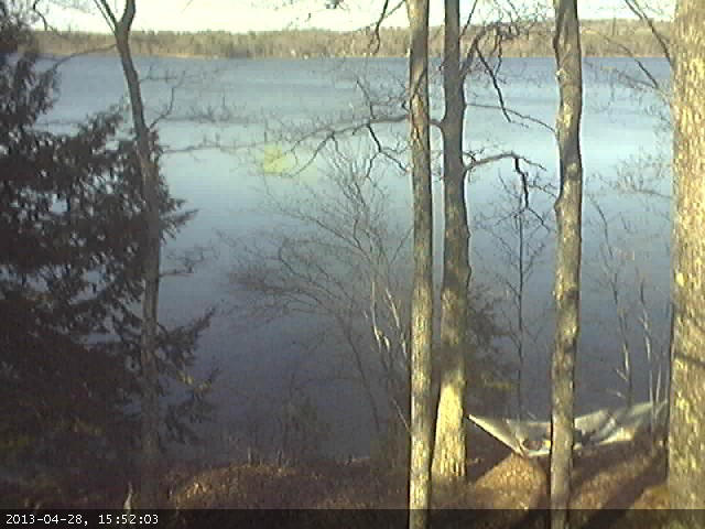 It seems like this April has been colder than usual, certainly colder than it had to be though that is just my opinion. Most everyone I’ve talked to seems to agree with me though. Anyways, it just seems like it hated to warm up this month and this in spite of the lack of rain. I usually think of April as a cold and wet month, but this one was just cold. We’ve only received 1.58″ of rain so far, well below normal. In the past couple of days though the weather sure has taken a turn for the better and it looks like we’re in for a good stretch of warm, dry weather. People are out fishing, putting docks in, and cleaning up around their yards. It’s nice to see activity around the lake again. I for one constructed a slip for my boat and hung my hammock today. I was somewhat chagrined to see that the hammock (and anyone laying in it) it is visible on the webcam. Not sure how I feel about that.
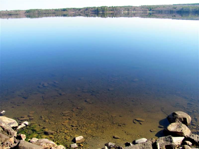 The lake was like a mirror this morning and the sun was bright. I was sitting down by the lake having my coffee and contemplating where we’ve been with this water level petition so far, and where we’re headed. And of course, I couldn’t help but notice how bloody shallow the water is on my shoreline. The picture at left tells the story. The water level is currently 44.25″ below the top of the dam and falling about 3/4″ a day. 25′ off shore the water is less than 2′ deep, and that’s about as close as I can get to shore with my boat without pulling the motor up and rowing. Everyone around the lake is in the same boat. As it were. More or less. Some have more water, some have less.
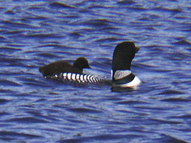 I was looking through an old Association photo archive the other day I and came across 4 pictures of loons with a baby. The pictures are dated July 14, 2003 which is very likely the last time we had a baby loon on the lake. If anyone knows who took them, please let me know so I can give them credit. I’ve added the pictures to the User Uploads Gallery. Let’s hope the pair of loons on Clary Lake this spring have more luck nesting than they did last year. They need a stable water level. It doesn’t look like they’re going to get that this year.
The week ahead promises to be action packed with something happening it seems like every day. Tomorrow there are 3 letters going in the mail. As soon as they have been mailed (and emailed) to their intended recipients, I’ll post them on the web site. Tuesday night is Whitefield’s Information Public Meeting, 7 PM at the Whitefield Fire & Rescue building on Town House road. Wednesday we get the Department’s responses to my and Paul Kelley’s comments on the bathymetric survey. That should be interesting.
Thursday I’m going fishing.
I am more firmly committed to resolving this Clary Lake water level crisis now than I have ever been. I’m not tired, nor disappointed with where we are in the process. I believe DEP is acting with the best of intentions and with the importance of Clary Lake’s valuable wetland habitat, and the best interests of the general public firmly before them. While the situation is still fluid and somewhat confusing with the 2 different petitions underway, I see a path forward through the confusion and I am more confident of the ultimate outcome now than ever before.
21 April 2013: Howard Nickerson: What price are we willing to pay?
 I was visiting Jane Chase this morning and she happened to mention an impassioned letter to the editor of the Lincoln County News that she’d read recently that did not ring a bell with me. Sadly, as much as I try and stay on top of everything going on these days, I just can’t and I rely heavily on other people to let me know about things of importance to Clary Lake and the water level petition. Jane found a copy on line and sent it to me. The letter to the editor turned out to be by none other than my good friend Howard Nickerson and was sent to the paper back in the middle of March. My apologies for just now getting it posted.
What price are we willing to pay?
Howard owns land up in the northeast end of the marsh on the east side of Clark’s Meadow Brook adjoining land of Sue McKeen and Butch Duncan. He’s a life-long conservationist.
20 April 2013: Added some more photos to the Chase Family Archive
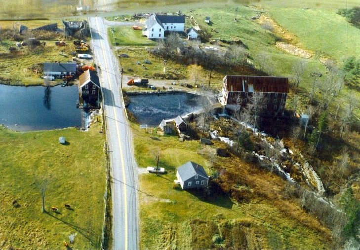 Jane Chase was kind enough to loan me some more pictures to put up on the site, quite some time ago but I’ve been kinda busy and haven’t had a chance to scan them until tonight. I’ve added 6 new photographs to the Chase Family Archive; 4 of them appear to have been taken at the time of a decent sized flood event and includes one aerial photograph showing water pouring over the Clary Lake dam (see the picture at left). You can also see in it the original stone dam below the mill building which likely dates back to the late 1700s or early 1800s, the remains of which are there today.
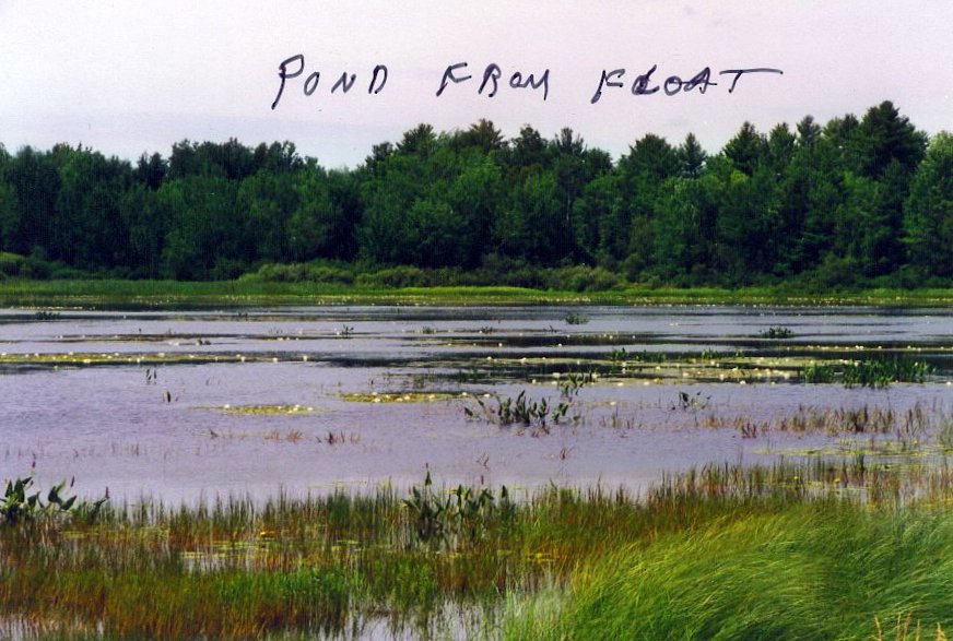 Perhaps of the 6 photographs I added tonight, the one I like the most is this one at left, a simple photo of the marsh with water lilies and marsh grass and nothing really special about it except for Chester’s hesitant handwriting scrawled across the top “Pond from float” and that Chester took this picture and clearly appreciated the beauty of the scene. I believe it was taken from his landing looking across the marsh at the Floge and Burns properties. Thanks again to Jane Chase for sharing these pictures.
13 April 2013: Low Water having an impact on wetland vegetation

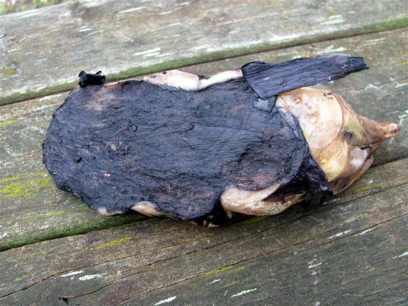 one that looks quite like this; then again, the other Yellow Pond Lily rhizomes I’ve seen were more mature, much larger and long, several feet or more in length. Perhaps this is what they look like when they’re young and just getting a foot-hold (pun intended) in the marsh. I’ll bet that’s it. Here’s a picture of the underside of the root.
There have been quite a few of the Yellow Pond Lily rhizomes getting washing up on the shore, more evidence of the impact the low water conditions are having on the sensitive wetland habitat around Clary Lake. The low water conditions exposes the roots to the elements and ice and rain erodes the soil holding them in place. Then they wash into the stream and float away. I’ve posted pictures here before of these rhizomes. Here’s a picture of some that floated down stream to collect at the dam. I’m half inclined to see if these can be collected and replanted. Seriously.
02 April 2013: Ice Almost Out

David Hodsdon keeps track of the “official” ice-out date. Last year the lake became completely ice-free on 21 March which is on the early side. More normal is between the 2nd and 3rd week of April. Here are Ice-Out Records going back to 2001.
16 March 2013: Ruminations on a Water Level Regime
The rapid rise of the water level of Clary Lake from -54″ below the top of the dam to -38″, a rise of over 16″ in just 3 days from only 3/4″ of rain and a little snow melt perfectly illustrates why Paul Kelley’s plan to “manage” the lake’s water level is both ill-conceived and fatally flawed. Kelley would like to maintain the lake at a low enough level so he can capture any conceivable amount of rain and runoff without it over-topping the dam. He could then release the water at a rate that wouldn’t overload the ability of the mill pond on the west side of the road to handle the discharge. According to Kelley, the mill pond can only pass 55 cubic feet per second of flow from Clary Lake without flooding his building and causing damage to the foundation. Kelley is currently doubly confounded because of the hole in the dam: he’s not just trying to keep the lake from over-topping the dam, he’s trying to keep it from getting within 3 feet of it. The water is already within inches of reaching the hole. He’s playing a very dangerous game.
If Kelley really wants to protect his mill building from high water damage, perhaps he should follow the advice in his own bought-and-paid-for URS engineering report and re-install the original overflow weir in the lower mill pond and not try to manage the outflow from Clary Lake over which he has no real control.
Clearly, if the lake can rise 16″ from what can only be characterized as a very small spring rain storm with a minimal snow pack, how much could it rise from a large spring rain storm when there’s a deep snow pack with saturated ground? We may get a chance to find out sooner rather than later: predictions for this coming Tuesday are for a wet spring snow storm and depending on which model you use could drop 15″ of heavy snow on us (the European model) or 4″-8″ of mixed snow, sleet, and freezing rain (GFS, or Global Forecast System model). The difference between the models is one of temperature; the European model forecasts a colder storm with snow throughout the region whereas the GFS model forecasts a warmer storm with snow inland and more rain and sleet towards the coast.
03 February 2013: 300 acres of drained wetland
I went for a walk in the meadow this afternoon, to the confluence of Clark’s Meadow Brook with the stream flowing out of Clary lake, to see what I could see, and
 even though I pretty much knew what to expect, it was still a shock to see what was once a viable productive wetland drained, exposed, violated. The magnitude of the ongoing environmental disaster that Paul Kelley has visited on Clary Lake is criminal. It is hard to believe that he cannot be held liable for damage to the environment as a result of the way he chooses to manage the water level of Clary lake. We all know what would happen to any one of us if we went to drain even a small wetland on our property or cause erosion or sedimentation of State waters through our action or inattention, and yet this man can actively destroy 300 acres of wetland and wildlife habitat with apparent impunity.
There is plenty of evidence of erosion where rain and melt water has pooled and run off into the main stream, cutting deep channels through the soft mud and exposing the roots of wetland plants. This soil erosion has no doubt caused significant sedimentation of the outlet stream and below the dam, the Sheepscot River itself. There are also large areas where water has pooled temporarily and in so doing has deposited a thin layer of sediment on the ground. This sediment will also wash into the outlet stream with the next rain causing further sedimentation of areas down stream. There are some more pictures of this in the Winter 2013 album.
I saw no wildlife save for a bald eagle that flew by, checking me out before heading into the trees over on the Floge property. I did see one abandoned muskrat house- I expected to see more but it appears they were driven from their regular habitat by low water last fall before they could build any lodges. It’s a hard winter on the furbearers.
I also took a series of 10 pictures and then stitched them together into a 360° panorama which is stunning if I do say so myself. The pictures were taken right at the confluence of Clark’s Meadow Brook and the main channel coming out of Clary lake. I scaled it down considerably from it’s original (huge) size and it’s still big- almost 2 megabytes. Hope you enjoy it.
There are other pictures in the Winter 2013 album. As usual, your comments are welcome. Many thanks (again) to Jane Chase for providing access.