Yearly Archives: 2014

2014 Water Level Charts Archived

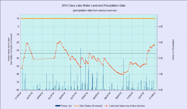
And so we come to the end of another month, and for that matter, another year. I’ve just posted the 2014 chart (below) in the 2014 Water Level Charts album. This makes the third full year that I’ve been recording Clary Lake water levels. You’ll notice that last winter I stopped making water level measurements in early February and didn’t resume until April

1st due to cold weather, deep snow, and (for a while) ill health. I’ll keep measurements up as long as practical this winter but I imagine when winter really sets in that I’ll take a break and resume when weather permits.

12 waterlevelchart_December2014The December 2014 chart (at left) is interesting. The rainfall we received back on the 9th of the month and over the next few days, though only 1.78″ in total was enough to bring the lake level up fully 16″ and to within an inch of 2 feet below the top of the dam for a runoff multiplier of 9 x (1 inch of rain = 9 inch rise) due to partly melting snow but mostly just because the ground was frozen. In other words, little if any rainfall soaked into the ground. It all ran off (the runoff multiplier during summer months is generally more like 4 x). Subsequent additional rainfall brought the lake level to 22″ below the top of the dam, right about where it would be this time of year if the Water Level Order being adhered to.

I’d also like to take this opportunity to wish everyone a safe and happy New Year’s Eve and a happy and productive New Year. I sincerely hope that 2015 sees the Clary Lake water level order implemented, the lake level restored, and a satisfactory resolution of all the issues surrounding the Clary Lake dam, for all parties. The Clary Lake Association is diligently working to bring these things about. With your help, we will succeed.

21 December 2014: Two days in the life of Clary Lake, December 2014

Having (almost) nothing better to do for the last few days than put wood in the stove and read, I decided to make a time lapse video with pictures from the Clary Web Cam. The time period covered is December 14th and 15th from 5:00 AM in the morning till 6:58 PM at night with a picture being taken every 2 minutes. It’s pretty exciting stuff. For example, about 12:30 PM on the first day, a water drip runs down the glass and when night falls, you can see a couple of lights on in houses on the other side of the lake 🙂

The technical stuff: the video is composed of 838 pictures being viewed at 24 pictures (frames) per second. That works out to just a hair over 34 seconds of riveting video excitement. You’re welcome 🙂

08 December 2014: Ice-In date of December 6th finally determined

The official 2014 ice-in date has finally been determined to be December 6th and I have updated the Clary Lake Ice-In and Ice-Out accordingly. While the lake was completely frozen over on the morning of November 29th, more than 1/2 of the lake melted off 2 days later when the temperature rose into above 40° for a couple of days, accompanied with some rain on top of that. Since then the lake has struggled to completely freeze over again until last Saturday morning when it finally seized up tight. Since then it’s put on quite a bit more ice. It was only 5° this morning as the cam pic at left will attest. 

The ice isn’t the greatest for skating this year and the weather coming in tomorrow (snow, sleet, freezing rain) isn’t likely to make it any better. We only get really good ice 1 year out of 3 or 4. Here’s another video I found from December 2010 to show you just how good it can get:


November 2014 water level chart archived

11 waterlevelchart_November2014

November 2014

And so we come to the end of another month. You’ll find the November 2014 water level chart in the 2014 Water Level Charts Album. The lake level stayed in a fairly tight range for the entire month, right around -50″ below the top of the dam, give or take a few inches. It got as high as -48″ at one point and low as -52″ below the top of the dam. With only 2.66″ of precipitation for the month (average is 4.36″) you’d have expected the lake level to have fallen more. However, the ground is fairly well saturated from heavy October rainfall so most of the precipitation we received ran off into the lake. Also, the lake only falls about 1/2 inch per day when it’s at this level so it doesn’t take much precipitation to keep the lake level constant.

And that’s the way it looks from here.

30 November 2014: Clary Lake iced-in

Clary cam - 2014-11-29 15.44.47Clary Lake was completely frozen over the morning of November 29th and well-below freezing temperatures all day undoubtedly added to the thickness of the ice coating. A lite dusting of snow coated some pre-existing ice the night before, as the cam picture at left shows. I was going to post this yesterday but David Hodsdon thought we should wait to see if the ice survives today’s temperatures at or above 40°. If so I guess we can consider it iced-in for the duration. David Hodsdon has been keeping track of Clary ice-in and ice-out dates for the past dozen or so years.

It’s too soon to tell if we’re going to get ice worth skating on. Only about 1 year out of 3 does the lake freeze over smoothly enough and stay snow free long enough to provide for good skating. And when the conditions are right for skating you need to get out and enjoy it because it won’t last long. Here’s a video I took back in December 2010 when conditions were just about as good as they get. It features me on camera and my wife Margaret pushing a chair (which is how most of us older folks ought to be skating anyways):

 I’ll post a few more when I get a chance.

27 November 2014: Happy Thanksgiving from the Clary Lake Association

Snap_20141127-072645_ThanksgivingHappy Thanksgiving everyone 🙂 I went out this morning and thawed out the Clary Webcam which was operational, but snow-covered. I thought I’d post a picture of what the lake looks like this morning. At the top of my list of things to be grateful for today is that we still have electricity (and internet) after last night’s snow storm. This means we will be able to bake the turkey we’ve been defrosting for the past 3 days and not have to resort to sitting down to a turkey made out of hotdogs:

o-HOT-DOG-TURKEY-CUT-UP-570

I don’t know about you, but I’d sit down to a bowl of Cheerios for Thanksgiving Dinner before I’d resort to a turkey made of hotdogs. Know what I mean?

Be well, stay warm, and be careful if you’re traveling today.

19 November 2014: A little ice around the edge of the lake

campic_19November2014

Skim ice!

For the first time this fall that I’m aware of, the lake has a little skim ice around the edges this morning. I hadn’t thought the water had cooled off enough to freeze because I was seeing lake-effect warming just the other day. I guess it is ready to freeze up! I remember years ago ice skating over Thanksgiving. I wonder if I’ll get to do that this year? According to our ice-in, ice-out records which go back to 2001, The earliest the lake has fully frozen over was back in 2002, on November 29th though last year it froze over on November 3oth.

16 November 2014: Clary Lake Association eligible for donations through AmazonSmile

The Clary Lake Association is happy to announce that they are now eligible to receive donations at no cost to you in the form of a small percentage of your purchases on AmazonSmile. For those of you who have never heard of AmazonSmile (I hadn’t until a few days ago), it’s simply another way to shop at Amazon.com with the difference that anything you buy on Amazon.com you can buy on AmazonSmile and Amazon will donate 0.5% of the purchase price to the charity of your choice! We of course would hope that you select the Clary Lake Association as your preferred charity, but you are free to select any charity you wish. All you need is an Amazon.com account.

You’ll notice a new AmazonSmile banner over on the sidebar, just to the right (under What’s New”) just like the image at the top of this post. When you click on that banner image you’ll be directed to smile.amazon.com pre-configured with the Clary Lake Association’s ID so you can just start shopping. You can also share that link with your friends and colleagues so they too can contribute to the Association:

http://smile.amazon.com/ch/01-0495730

Now, 0.5% doesn’t amount to a lot of money on any given sale (only 50 cents on a $100 purchase), and our user base at present is rather small but if you use it, and you ask your family and friends to use it, over time, it can add up to real money. I have the distinction of being the first person to use AmazonSmile to contribute to the Clary Lake Association; earlier today I ordered a linquini attachment for my Marcato Atlas pasta machine, something I’ve been wanting for a long time. It cost $39.95 and the sale resulted in a $0.19 donation to the Association 🙂

Remember, it costs you nothing to contribute to the Clary Lake Association through AmazonSmile.

For more information about AmazonSmile check out their About AmazonSmile page.

11 November 2014: DEP issues Lake Elevation Survey

The Department of Environmental Protection has released an Elevation Survey for Clary Lake dated October 28th conducted by CES, Inc. , a consulting engineering and surveying firm with offices in various cities around Maine. The field work for the survey was conducted in the vicinity of the State boat launch on October 14th and refers to engineering work completed back in 2002 during the construction of the boat launch. The elevations on the survey are referenced to the NAVD88 elevation datum and are based on GPS measurements.

Special Condition 4 of the Clary Lake water level order required the dam owner to retain the services of a licensed professional land surveyor to establish the historical normal high water line of Clary lake. This survey was to have been completed and submitted to the Department by June 2nd of this year. Since the dam owner failed to complete the work as required, the Department of Environmental Protection has done so. This is a welcome development.

The survey concludes that the crest of the dam has an elevation of 151.17′ (NAVD88) and that the highest observed stain line on a rock in the vicinity of the boat launch has an elevation of 151.2′ (NAVD88). Thus, the survey has concluded that the historical normal high water line of Clary Lake is the same elevation as the top of the dam.

09 November 2014: New banner added to the site

cropped-Clary_Lake-in_winter_banner.jpgWith winter almost here, David Hodsdon decided to send me a winter picture of Clary Lake (thumbnail at left) which I’ve turned into a banner for the site. This one looks like a little better than 180° wide panorama. Love it. I usually rotate banners a random basis, but I’ve decided to leave this one up for a few days. Incidentally, all the banners on this site are pictures of Clary Lake (with the exception of the one taken by my friend Jason Simonds of 2 bald eagles sitting in a tree down in Damariscotta Mills).

03 November 2014: Clary Webcam temporarily down

campicA number of people have been viewing the Clary webcam during and since the storm, only to find the picture at left. You’d think the camera was snowed in when in fact the webcam is working fine and it’s a beautiful day on Clary Lake. The picture you’re seeing is what the world looked like at 11:30 am yesterday morning when Time Warner’s cable service went down. It is still down so new campics aren’t being uploaded to the site. This is a temporary condition, though it can’t be too temporary for my liking. I’m posting this from work.

October 2014 water level chart archived

10 waterlevelchart_October2014I’ve archived the October 2014 water level chart. The lake started the month down about as low as it can get, around 60″ below the top of the dam. It has only been that low 4 other times in the past 3 years. This condition was the result of having received less than average rainfall in August and almost no rain (<1″) in September. While August and September were both short on rainfall, so far this year we’ve received a total of 39.40″ of precipitation, almost an inch more than normal.

12 October 2014: Clary Lake Webcam back in operation

The Clary Lake webcam is back in operation, at least for the time being. We’ll see how it fairs when really cold, inclement weather gets here- I may have to move it indoors but for now it’s up and running. It’s not an optimal setup by any means but the picture quality is a whole lot better than the old webcam and the view is much improved too: wider, higher resolution, less trees, more lake. In fact, the image is so wide it won’t fit on the page completely without cropping. I’ve put a link to the actual image on the webcam page so you can download the full-width original.

Unlike the old webcam, this is a standalone wireless camera and doesn’t rely on a resource-hog of a program to compete with me for CPU cycles, monitor the camera, take the pictures, and upload them to the web server- all that functionality is built into the camera. This will make it a whole lot more reliable. I can also remotely mess around with the camera, changing the picture size and where it’s pointing, and zoom in and out.

A planned future enhancement: installing a staff gauge in the field of view so you can remotely view the current lake water level. That would probably not work well in the winter when the lake is frozen.

04 October 2014: Who says the State boat launch is unusable?

IMG_4337 (Custom)Jack Holland called me earlier today and told me to get over to the boat launch and bring a camera. I didn’t stop to ask questions, I just dashed off. Well, the scene I encountered when I arrived there a few minutes later defied comprehension (see picture upper left). Nonplussed, I decided to just shoot first and ask questions later (you’ll find them in the new Fall 2014 gallery). I also decided to shoot a couple of videos. The first one shows them hauling the Cat loader out of the muck:

I was surprised and impressed those 2 trucks managed to drag that loader out, I’m pretty sure it weighed more than both trucks put together. Then with the loader out of the way, they were able to address the pickup truck problem:

I guess this situation would be funny if it weren’t so tragic. Backing your truck into the lake to get your boat because there isn’t enough water at the end of the ramp was not a great idea, getting stuck was virtually guaranteed. Getting the Cat loader stuck was inevitable once the (bad) decision was made to drive that into the lake to pull out the truck. Then they called dad.

These kids were fortunate really, nobody injured, nothing lost but face. Oh. And a broken drive shaft. And a tow rope. They stirred up a plume of clay sediment (visible in the above video) that will take a while to settle out and they’ve left some ruts in the lake bottom that will be there for years to come, but to put things in perspective, really, the environmental impact of their silly escapade is inconsequential in comparison to that being visited on Clary Lake by the dam owner himself, and through their inaction, the Department of Environmental Protection. Kids will be kids. While it is easy to be critical of their behavior, I can remember doing some pretty stupid things myself when I was young. Nothing like this of course.

03 October 2014: The lake is about as low as it’s going to get

The other day I posted the September Water Level Chart and I speculated at that time that I thought the lake was about as low as it is going to get. Tim Harkins had related how he’d tried to get into the channel and couldn’t find it. Well today I headed out in my kayak to the northwest end of the lake to try to find my way into the channel. I couldn’t. I could see where the water was flowing, but I ran aground in about 3″ of water trying to follow it. I didn’t push it because I didn’t want to get stuck.

The rate at which the lake level has been falling has been dropping off rapidly and as the following plot shows, it has about hit bottom:

water_fall_rate_plot1

Plot of water level versus day number.

The chart shows 36 days of falling water levels starting on August 16th and extending through today. Now I’m not saying the lake can’t fall any lower, but from the looks of that curve it is unlikely. Theoretically it could drop another couple of inches if we continue without receiving any rain, but that is unlikely. Without any rain, springs and water seeping out of the water table is sufficient flow to offset the 1/8″ per day the lake is falling.

What it interesting is that back in April 2012 the lake level fell to 62.25″ below the top of the dam, 2″ lower than it is now. It is hard to imagine the lake falling that low again. I suspect the sediment “dam” blocking the channel is the result of ice pushing against the lake bottom.

02 October 2014: Another lake shore owner writes State

Another impassioned email this one from Clary Lake shore owner Rick Gallion, confounded by the low water conditions and the apparent lack of any enforcement action being taken against the dam owner by the Department of Environmental Protection. We know from Beth Callahan’s response to Jean McWilliam’s letter from the other day that the State has decided to hold off on enforcement action against dam owner Pleasant Pond Mill LLC pending the outcome of currently ongoing mediation. While this approach is somewhat understandable, it doesn’t make the situation out here on the water any easier to take.


September 30, 2014

Beth,

     I wanted to alert you as to the seriousness of the low lake level of Clary Lake.  Last weekend I  only managed to get my small sailboat out of the lake with great Gallion01difficulty, and possibly some damage because, as you can see, the level of the lake at the public boat launch is extremely low.  A fisherman behind me had difficulty even getting his shallow draft, metal hulled fishing boat out.  In the photo of the grassland with the lake in the distance, the water is usually nearly up to the photographer, and the wetland is teeming with wildlife.

     There was a family at the boat launch and the children were trying to swim.  One of them asked his mom “Where’s the water”.  On a day as nice as it was that Sunday, there would usually be several family groups there enjoying the lake.

      My wife and I own the Clary Lake Bed and Breakfast in Jefferson, very near the lake. Our business has suffered the last several years because people have stopped Gallion03coming to visit families and friends who have camps on the lake.  I have been unable to use my sailboat because the level is so low throughout the lake.  I only put it in this year so that I could give my nephew from Kansas a sailing lesson, but I was very limited on where I could sail, and I won’t be able to use it until the lake level is restored.

     I know that you and your department have been working very diligently on a lake level order for Clary Lake, and I do appreciate your efforts.   I also know that Gallion02the owner of the property that the dam is on continues to find new and different ways to delay and impede the process.  My hope is only to remind you and your department of the negative effects that the mismanagement of the Clary Lake dam has had and continues to have on real people, in hopes that it may encourage you to make every effort to expedite the process, so that Clary Lake will once again be a fine recreation destination for the area, and the state.

Thank you.

Sincerely,

Rick Gallion
Clary Lake B&B
777 Gardiner Road
Jefferson, ME 04348
207 549-5961


01 October 2014: September water level chart archived

9 waterlevelchart_september2014I’ve just archived the September 2014 water level chart… and what a month it was. The effect of only having received 0.95″ of rain for the whole month (average is 3.74″) is painfully evident in the slowly but steadily declining water level over the course of the month. The water level is currently 60.24″ below the top of the dam. It can fall further, but not a whole lot further: an examination of the data used to create the chart shows that the rate at which the lake is falling is dropping off fairly quickly. At the beginning of the month it was falling between almost 3/4″ per day. Now, at the end of the month, it is falling about 1/4″ per day. At that rate, it won’t take much rain at all to offset the drop and the lake will bottom out, and stop falling. Last Friday Tim Harkins told me that he’d tried to get up into the meadow in his kayak but was unable to find the channel.

The likely explanation for the situation Tim encountered is that low water conditions combined with ice over the past couple of winters have caused the bottom sediments in the vicinity of the outlet to be pushed up forming a bar of sediment and that this bar is blocking the outlet channel, impeding the flow of water out of the lake and limiting how low the lake get get. This same mechanism- ice pushing against the lake bottom over time- is likely what created the sand bar that can be seen down by the State boat launch. In that case, there was enough water flowing into the lake to cut a channel through the sand bar. It remains to be seen if there’s enough water flowing out of the lake to do the same thing. I doubt it.

Two years ago the lake got down to 63.25″ below the top of the dam. Realistically I don’t think it can fall that low again, but I might be wrong. In any case I intend to go out and try to find the channel myself, later this week. Stay tuned.

29 September 2014: Irate Lake Shore Owner sends letter to DEP

I received the following email today sent by Clary Lake shore owner Jean McWilliams to Beth Callahan of the Department of Environmental Protection. Jean has every reason to be upset. We all do. One does have to wonder what the DEP is waiting for: the lake can’t get much lower.


September 29, 2014

Dear Ms. Callahan:

I am writing as a waterfront property owner on Clary Lake. I want to share my prospective as a resident on Clary Lake who has enjoyed this (previously) unspoiled lake for over 20 years. 

Jean McWilliams' water lineThis past weekend was warm and glorious and I planned to spend the weekend at our camp. Imagine my surprise when upon starting the water pump, there was no water. The first enclosed picture shows why;  the water line was fully out of the water. I have already extended the line once since the near draining of the lake. Apparently my family won’t be able to use the camp for the rest of the season, thanks to Paul Kelley’s actions.

Jack Holland's boatI’ve also attached a picture of my neighbor’s boat, high and dry as you can see. I am now 66 years old and have always planned to sell the camp in order to retire. As you can well imagine, property on Clary Lake is not exactly in demand.  So much for retirement, and again, thanks to Mr. Kelley. I am simply stunned that this situation has continued for over 3 years. The DEP has issued a water level order.  Mr. Kelley has ignored it.  He clearly does not care about the environmental, economic and recreational damage his actions have caused. I strongly urge you to enforce the water level order and insist that Mr. Kelley follow the law.  The blatant actions of this man are unacceptable and I ask that you enforce any and all regulations broken by Kelley.

Sincerely,

Jean McWilliams


Whitefield Selectman’s Meeting Agenda for Tuesday 23 September 2014


Below is a tentative agenda for Tuesday’s meeting:

Town of Whitefield Selectmen’s Agenda
September 23, 2014

Item Time Agenda Item
6:00 pm Call meeting to order
Sign Minutes 9/9/14
6:05 pm Sign Warrants Accounts Payable/Payroll
6:15 pm Fuel bids
6:20 pm Roadside Brush cutting
6:30 pm Paul Kelley RE: Building transfer
7:00 pm Fred Duncan RE: Senott Rd./DEP Letter/Tax issue
7:15 pm Discussion

a. Inter local community cooperation
b. Next Week’s Agenda
c. Other
8:00 pm Adjournment