Yearly Archives: 2014

22 September 2014: Kelley Files Consultation Report with DEP

Paul Kelley has fulfilled the final statutory requirement of his Petition for Release from Dam Ownership or Water Level Maintenance by filing his consultation report detailing the results of his attempts to find a new owner for the Clary Lake dam. This concludes a process that he started over a year and a half ago. He filed the report late last Friday afternoon, 19 September 2014. I obtained copies of the report from the Department of Environmental Protection earlier today. I haven’t had a chance to read these reports yet, but I’m certain he will state that he’s met all the statutory requirements of the law, has found no one willing to assume ownership of the Clary Lake dam:

Of course, it’s a well-known fact that the Clary Lake Association would like to own the Clary Lake dam. However, anyone who has been on the receiving-end of Kelley’s sales pitch can only conclude that he really doesn’t want to sell it at all. Kelley’s petition has been written about numerous times on these news pages; if you want to find them select the category “That Other Petition” in the right side bar, or follow this link.

10 September 2014: Updated Bathymetric Chart available

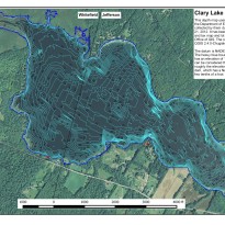
Clary_Lake_Depth_Map_with_aerial_SMALLI’ve updated the recently released bathymetric chart with new contours using some additional data in the vicinity of the ledges at the northwest end of the lake and a few other rocks. The revised contour map now clearly shows both those ledges and the rock currently marked by a white buoy in the vicinity of the Whitefield/Jefferson town line near the north shore. Also, the 148′ and 146′ contours have been replaced with 1′ depth contours making this version of the chart more accurate in depicting the shallow water around the shoreline. I will, as time permits, further refine the underlying data.

If you’re not seeing version 0.2 dated 09/10/2014 (check lower left hand corner) try clearing your browser’s image cache.

Several people asked about getting a contour map superimposed on an aerial photograph. No problem! There are now two images available, a large scale one and a smaller more manageable image (click on the thumbnail at upper left). They’re also available on the Maps, Charts, and Graphs page. You’ll also find a .KMZ file there which you can load into Google Earth.

06 September 2014: New Clary Lake contour map finally available

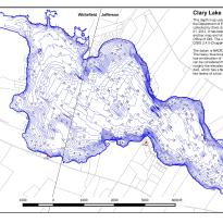
Clary_Lake_Depth_MapI have finally gotten around to generating a contour map of Clary Lake using data collected by the Department of Environmental Protection during their September 2012 bathymetric survey. In addition to the high resolution image pictured at left there’s a smaller version available, and a 24″x36″ PDF which is quite large but which can be viewed or printed out at about any scale you wish. Feel free to download them, you’ll find them and the other files pertaining to the original bathymetric survey over on the Maps, Charts, and Graphs gallery. Each image has a link in the description field to the full-sized image.

The data set consists of 3,265 points with each point defining a 3-dimensional location on the face of the earth (i.e., the latitude, longitude, and water depth below the top of the dam). The depth was measured with a depth meter and each depth measurement was paired with the latitude and longitude of the point obtained via GPS receiver. The data in the form of a spread sheet was supplied to us back in April 2013 along with a colorized bathymetric map of the lake generated from the data. This map was a marked improvement over the original depth map of Clary Lake, prepared by the Department of Inland Fisheries & Wildlife back in late 1940s, but it lacks some real utility because it doesn’t show you what the bottom of the lake actually looks like- where the hills are, where the holes are, what the depth is at any given spot. According to the original depth map, the deepest spot in Clary Lake was only 23′ whereas we now know that the deepest spot is actually 29′ below the top of the dam. Continue reading

01 September 2014: August water level chart archived

8 waterlevelchart_August2014We’ve come to the end of another month, and I’ve archived the August water level chart. Despite the slightly less than average amount of rainfall in August (3.05″) and in spite of the fact that the dam’s gate has been wide open the whole time, the lake level remained in a fairly tight range of about ± 5″ for the month, starting out at a hair over 40″ below the top of the dam and ending the month a hair under 50″ below the top of the dam. In this range of water levels the lake tends to drop about 0.66″ per day, with the gate wide open. It doesn’t take much rain to bring the lake up a significant amount.

It is now just one month until October 1st, the date when the Clary Lake water level order is supposed to have been fully implemented. Given that Kelley has done absolutely nothing to implement the Order, it will be interesting to see what the DEP does when that date rolls around.

26 August 2014: Mapping DEP’s Bathymetric Data

In preparation for conducting a Water Level Survey sometime later this fall, I’ve put together an interactive map of the DEP’s bathymetric survey data using Google’s “Fusion Tables.” Each data point includes the latitude, longitude, and water depth in feet below the top of the dam. The data set consists of 3271 points, 6 of which I plugged in using data collected during our water monitoring activities. You can easily spot those as they fall in between the boat data tracks.

The deepest spot in the lake is about 28′ below the top of the dam. If your browser is failing to render the embedded map above, here’s a link to it:

Bathymetric Survey Fusion Table

The DEP conducted the field work in September 2012 and issued a colorized bathymetric survey the following spring. Eventually I will generate an actual contour map and also collect some additional data locating the rocks and ledges.

Maine VLMP hosting a Watershed Survey Workshop

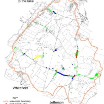
id-map-of-sitesEvery year in early September the Maine VLMP holds a Watershed Survey Workshop in conjunction with the Department of Environmental Protection. I attended one put on by the Damariscotta Lake Watershed Association this past spring and found it both educational and fun. Anyone planning on helping out with updating the Clary Lake Association’s 2001 Watershed Survey (tentatively scheduled for next spring) would benefit greatly from attending this workshop. Contact me if you have any questions or would like more information.


Watershed Survey Workshops

2014 Watershed Survey Training Workshop

How to Identify, Monitor and Mitigate Ways in Which Watershed Land Use Influences Lake Water Quality

Fri. September 12, 10AM to 3PM – VLMP Lakes Center, Auburn

WatershedSurveyPicNewBkgdVirtually all of the natural characteristics of a lake are influenced by the land area, or watershed, that drains to the lake. But human activities that alter the natural protective features of lake watersheds can result in significant degradation of water quality and aquatic habitat over time, unless conservation measures are undertaken to protect the lake. This workshop will cover basic information about the relationship between lakes and their watersheds, common threats to lake water quality from watershed development, and how to identify and resolve problems through the watershed survey process. We will begin with an inside discussion, followed by a field trip to a nearby lake watershed.Please bring a brown bag lunch. 

Pre-registration is required. To register please contact the VLMP office at 207-783-7733 orvlmp@mainevlmp.org.

18 August 2014: Whitefield Selectmen write the AAG

The Whitefield Selectmen have sent a letter to Assistant Attorney General Thomas Harnett, the person handling the Clary Lake water level order and its pending appeal filed by Paul Kelley in Lincoln County Superior Court. The letter urges the AAG to expedite the current mediation process and enforce any violations of the water level order that may be found to exist.  It was sent by email to the Service List. It has also just been posted on the Town of Whitefield’s Facebook page. It’s short and sweet so I’ll copy here in its entirety:


Thomas Harnett
Assistant Attorney General
Department of the Attorney General
State House Station 6
Augusta, Maine 04333-006

Dear Mr. Harnett:

The Town of Whitefield would like to convey to you its continuing concern about the
present state of water levels in Clary Lake. Since 2011, the lake level has been lowered and resulted in continuing and significant impacts to the environment and our community. Without going into details as they are well documented in the record, the low water level has adversely affected Clary Lake’s suitability for recreation, navigation and as a habitant for fish and other water dependent species. While the dam has been described by the owner as “breached”, it is in fact just damaged and reparable.

The Town is asking that your office actively use all means at its disposal to resolve
pending issues in order to restore Clary Lake water level to that which existed prior to 2011. In particular, your assistance in the expediting the current mediation process and enforcing any violations of the DEP’s water level order that may be found to exist would be appropriate and appreciated.

Thank you for your consideration and assistance.

Sincerely,

Aaron Miller
Administrative Assistant to the Select Board
Town of Whitefield
cc: Service List


“Damaged and reparable.” Nice they got that bit in there.

The Selectmen voted to send a letter last week at their regularly scheduled Select Board meeting. That meeting was covered by the Lincoln County News (see: Whitefield Selectmen to write State officials about Clary Lake). I greatly appreciate the Whitefield Selectmen taking this assertive step.

Here’s a link to the actual document:

18 August 2014: Clary Lake Association requests change to Service List

img_2254__medium_Almost from the beginning of the Clary Lake Water Level Petition, attorney and Clary Lake shore owner Robert Rubin has served as counsel for the Association in their role as intervenor in the petition proceedings. His advice and assistance over the past two and a half years on behalf of the Association as well as to me personally in my role as Petition Spokesperson has been invaluable and was instrumental in bringing the Clary Lake water level petition to a successful conclusion. I consider him a good friend and we all owe him a debt of gratitude for his selfless service to the Association and for his commitment to the preservation of Clary Lake.

Well, Bob has been making plans to retire for some time now, and he has finally gone and done it: he is no longer practicing law. His wife, Cheryl Ayer, a practicing attorney and recently elected Clary Lake Association Board member, has agreed to take over the role of counsel for the Association as intervenor in the Clary Lake water level petition proceedings. To that end, I have sent a letter to the Department requesting they update their Service List to reflect this change in representation.

While the petition process is behind us (thank goodness), the Service List itself has not been dismantled and is still available for information distribution to certain State agencies and other interested parties, of which there are quite a few. Departmental procedural orders regarding the Clary Lake water level order will be sent to the Service List. This update also serves to remind the Department that the Clary Lake Association is still here, waiting, and watching.

16 August 2014: Algae bloom not getting any better

IMG_20140816_090956The algae bloom that appeared a few weeks ago (see 01 August 2014: Yet another algae bloom in progress) hasn’t gotten any worse, but it certainly hasn’t gotten any better either. Today’s secchi disk reading of 2.00 meters (6.56′) shows that the water transparency has only marginally improved from 2 weeks ago when it was 1.82 meters (5.97′). The green scum you’re seeing around the edges of the lake are the dead and decaying carcasses of the cyanobacteria (blue-green algae) that are responsible for the bloom. I took the picture at left this morning. Not very appealing.

It remains to be seen whether lake transparency slowly begins to improve or deteriorates further. I suspect, given the time of year and the low water conditions that we’re likely to see the bloom get worse as fall approaches. Both the Volunteer Lake Monitor Program folks and the Department of Environmental Protection are aware of the situation though it certainly wouldn’t hurt for a few more people to contact the DEP’s Division of Environmental Assessment and let them know what is happening. Here’s a link to their web page with instructions on how to report an algal bloom:

13 August 2014 Lincoln County News: Whitefield Selectmen to write State Officials About Clary Lake

George Fergusson, left, of the Clary Lake Association and Tom Hayes, Whitefield’s assessors’ agent speak to the Whitefield Board of Selectmen Aug. 12. (Kathy Onorato photo)

At their regularly scheduled meeting last Tuesday night, Whitefield Selectmen voted to write a letter to State officials expressing concern over Paul Kelley’s obstinate refusal to implement the Clary Lake water level order, according to an article in this week’s Lincoln County News by Kathy Onorato. In a brief telephone interview on Wednesday, Kelley complained about not having been notified that his company, Pleasant Pond Mill LLC, was going to be discussed at the meeting. For the record, I was at that meeting and the name “Pleasant Pond Mill LLC” was not mentioned once that I can recall though Mr. Kelley’s name was used numerous times. Also for the record, the Selectmen’s agenda was published on the Town’s facebook page on Monday. Apparently Mr. Kelley is not following that page:

Continue reading

08 August 2014: New Website Permalinks

Some of you might have noticed a change to the link structure in use on our website. The original “?page_id=266” and “?p=2243” links have been replaced with a human readable “post-name.” For the most part this will be transparent and not require any thought or action on your part. If you have links you’ve saved in your browser for favorite pages, they’ll still work, you’ll just be automagically redirected to the new link. For example, if you point your browser at:

https://clarylake.org/?page_id=266″

you’ll be redirected to:

https://clarylake.org/current-water-level-charts/

One of the reason for this change is to make the links more human-readable, the other is to take advantage of page caching which should help with site performance. I’ve done a fair amount of testing and I don’t think anything is broken but if you find something that isn’t working, please let me know. Thanks.

03 August 2014: Yet Another Successful Annual Association Meeting

We had a good meeting of the Clary Lake Association yesterday, reasonably well attended though I had expected a somewhat larger turnout given how much we promoted the meeting. I remain somewhat chagrined that so many Clary Lake shore owners either aren’t interested in joining the Association or just can’t be bothered. I’m also surprised that some folks actually show up for the meetings, but are still unwilling to join! What’s up with that? The Clary Lake Association is dedicated to preserving, protecting, and enhancing the natural beauty, and quality of Clary Lake and its watershed. Everyone who owns land on Clary Lake should be a member, without exception.

The membership unanimously voted to adopt the Proposed Revised Bylaws. After the work the Bylaws committee put in on them over the past year, it would have been disheartening to say the least if they had been rejected! Furthermore, we got some good feed back from the membership to guide the Bylaws committee in revising the Membership and Voting Rights language to be voted on at next year’s meeting. I’ll finalize the newly adopted bylaws and post them on the website as soon as I get a round tuit. Continue reading

01 August 2014: Yet another algae bloom in progress

Jack Holland and I performed out bi-monthly water quality monitoring boat trip this morning and obtained a secchi disk reading of 1.80 meters (5.9′) indicative of an algae bloom in progress. This does not come as a huge surprise since we’ve entered a bloom state about this time of year for the past 4+ years. Still, it was an unpleasant discovery. I’ve posted today’s data on the Clary Lake Water Monitoring Data page. Scott Williams of the Volunteer Lake Monitor Program has been notified of the bloom.

anabena03Algae blooms are caused by the out-of-control growth of blue-green algae known as cyanobacteria. The most common cyanobacteria is Anabena, shown at left. Algae feeds primarily on phosphorus washed into the lake by runoff  and released from bottom sediments in low-oxygen conditions. Undoubtedly the 7.65″ of rain and the resulting runoff we received in July contributed to this bloom, but the lower water levels resulting in reduced lake volume and sediments exposed to wave action and erosion certainly didn’t help any. Here are some pictures of what we can look forward to in about 2 weeks:

dead-blue-green-algae-21august2013img_3895-customimg_3897-custom


01 August 2014: So much for repairing the dam!

IMG_20140801_123916According to the Clary Lake water level order today is the day that Paul Kelley was supposed to have completed repairs to the dam and installed a publicly-visible water level gauge. As you can see from these pictures taken just a little while ago, he hasn’t even bothered to cut the tree down that is growing out of the dam let alone actually effect any repairs to the dam. Of course, I’m not surprised since Kelley has yet to do ANYTHING substantive to comply with any requirement of the water level order. Here is the specific section of the Order that relates to today’s deadline:

6. A permanently mounted lake level gauge shall be installed on the Clary Lake Dam by the owner of the dam. The gauge must be marked in tenths of a foot and placed in a publicly visible area on the upstream face of the dam near its outlet. The gauge shall be placed such that the normal high water line, as determined by the procedures outlined in Condition #3, corresponds to an elevation of 0.0 on the gauge. This measurement will be used as a benchmark for observing water level changes and may be used for measuring the height at which the dam gate must be opened above its invert. Provided that the normal high Water line has been established in accordance with Condition #3, the gauge must be installed immediately following completion of the dam repairs as described in Condition #2 or by no later than August l, 2014, whichever comes first.

IMG_20140801_124030Sounds pretty clear to me, but then what do I know? I haven’t heard anything about mediation that is supposed to have started last Tuesday, July 29th. As soon as I find out anything, I’ll post it here.

23 July 2014: Kelley responds to DEP June 19th Communication

Special Condition #4 of the Clary Lake water level order is a requirement that the dam owner have a Professional Land Surveyor establish the historical normal high water level of Clary Lake and transfer that elevation to the dam. The Order required that the dam owner submit this survey to the Department by June 2nd. Paul Kelley did in deed submit something on that date and not surprisingly, it failed to meet the requirements of the Order. On June 19 the Department responded with a letter detailing the shortcomings of his submission. The letter gave him 30 days, until July 21st, to correct the deficiencies in his submission and resubmit the plan. That was a couple of days ago. I got a copy yesterday afternoon and it is sadly but not surprisingly, more of the same old, same old:

Continue reading

22 July 2014: Enos Property on Clary Lake for sale

Imagine my surprise to find Arthur Enos has put his property up for sale:

$875,000.00 Request More Info
Current
Single Family
5 Br    0 Ba    ±4,000 sqft.
±17.000 Acr.
Clary Lake
MLS#: 1146688
 
Enos Lane is a beautiful year round residence located in Jefferson on Clary Lake. With approximately 17 acres of woods and views of the water, the property offers a secluded, landscaped setting at the end of a private drive with 700 feet of waterfront.

14 July 2014: Anyone missing their dingy?

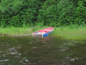
Your dingy?

This little dingy drifted up to the northwest end of the lake the other day and beached itself on Eleanor Goldberg’s property. She pulled it up on shore. If it’s your boat, come get it or if you know who it belongs to, let them know. Thanks!

Well that didn’t take long. Mystery resolved. It belongs to Rick Gallion 🙂

13 July 2014: Clary Lake has a new Certified Volunteer Lake Monitor

IMG_20140711_130559 (Custom)Clary Lake now has 3 volunteer water monitors certified by the Maine Volunteer Lake Monitor Program: David Hodsdon #HO-0042, Jack Holland #HO-0551, and as of last Friday 11 July 2014, myself (George Fergusson) #FE-2648. I’ve been meaning to pursue certification for some time but finally found the time and initiative to do so. At this time I’m only certified/qualified to collect secchi disk readings and surface-grab Total Phosphorus tests, but I plan to get qualified later this summer on the use of the Association’s YSI Pro20 digital dissolved oxygen meter and the more comprehensive core water sample technique for phosphorus.

Continue reading

11 July 2014 Kennebec Journal: Clary Lake dam owner and state still at odds

There was an article in yesterday’s Kennebec Journal by staff writer Paul Koenig providing a welcome update on the current circumstances surrounding the Clary Lake water level order. It is nice to see the KJ keeping this issue before the public, rather than letting it fade into obscurity. Paul Kelley was quoted as saying that mediation is to start at the end of this month and that the process is likely to extend into August: “My hope is that all the parties see that the best solution is no longer to fight this but to try to see if there is some constructive solution.” Nonetheless, the spokeswoman for the department said the DEP still expects the dam owner to begin maintaining the higher water levels by Oct. 1. Here’s a link to the article:

If anyone has trouble getting the article off the newspaper site, I’ve saved a local copy:

I was briefly interviewed by phone but I didn’t have a lot to say. The article does not mention whether the spokesperson for the Clary Lake Petitioners and/or the Clary Lake Association (as intervenors in the petition) will be asked to participate in the mediation. While I was quoted as saying that I don’t expect anything to come from mediation, that doesn’t mean I wouldn’t be willing to join in the process.

FYI, the next deadline for Paul July 27th when he has to resubmit his Water Level Survey (which was also deemed “unsatisfactory”) and then by August 1st he is supposed to have completed repairs to the dam, and installed a water level gauge.

The article also mentions the Branch Pond water level order and the recent letter from the Coombs. It remains to be seen how or if the Department chooses to respond to their “declaration.”