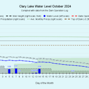
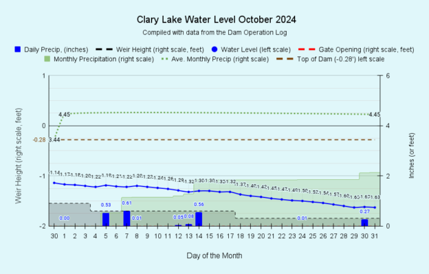
 I have archived the October 2024 water level chart (above, and at left). The dry weather we experienced in September continued into October which is normally one of our wettest months, second only to November in average monthly rainfall. All told we only received only 2.13 inches of rain in October. For the year we’re still about 8 inches above normal precipitation thanks to excessive rain in March, June, and August but rainfall for September and October combined is only 3.89 inches, 4.40 inches less than normal. Despite the shortage of rain this fall, it is likely that ground water supplies are still in pretty good shape but the ground surface is pretty dried out and the fire danger is high. The US Drought Monitor shows this area as being “Abnormally Dry” but in “Moderate Drought” just a mile to the east of Clary Lake.
The lake level has fallen steadily over the last two months at the rate of about 0.016 feet (0.2 inches) per day, This water loss is partly due to the dry weather we’ve been experiencing combined with some leakage and evaporation thrown in, plus we’ve been letting out a little water by gradually lowering the height of the weir. Normal rainfall is able to offset most of these water losses but we haven’t been seeing anything like normal rainfall for a while. The lake level started the month at -1.17 feet and dropped just under 1/2 a foot to end the month with the lake level down -1.63 feet, the lowest it’s been since we started managing the dam in 2019.
 As mentioned, our dam management strategy has played a part in the lower lake level too. While the gate has remained closed, we’ve been gradually removing stop logs every few weeks, starting in late September with the last stop log being pulled today, the last day of the month. Lowering the height of the weir sort of sets the “target” lake level. There are several reasons we’re doing this. There is reason to believe that dropping the lake a couple of feet in late fall into early winter is actually good for water quality the coming year. The reason for this is we’re dumping water that is relatively rich in Phosphorus that was released at the bottom of the lake over the summer in a process known as “internal phosphorus loading.” In the fall when the lake “turns over, this phosphorus rich water mixes with the upper layers where algae live, very often igniting algal blooms. As good as our water quality was this summer, this “shot in the arm” of Phosphorus still caused a minor “ephemeral” algal bloom in late September, a fairly “normal” occurrence for a Mesotrophic lake like Clary (see “Fall Turnover Causing Some Algae Growth“). The water we’re dumping will be replaced, hopefully with water that has less Phosphorus in it! That’s the theory anyways. Runoff from rain and snow melt will have some Phosphorus in it whereas ground water has little if any Phosphorus, or anything else for that matter,
The water level order gives us the discretion of dropping the lake up to 1 foot from ice out in the spring until July 31st, and another foot for a total of 2 feet after August 1st and before ice-out in the spring. This water level regime is supposed to mimic the natural water level fluctuation that occurs in typical Maine lakes over the course of the year. A lower level in the fall is generally recommended to accommodate fall rains to prevent flooding, and in the winter to minimize damage to the shoreline and dam from ice which can exert considerable destructive force against whatever it’s pushing on (see “Ice Berms & Pressure Ridges“).
 We have another reason for lowering the lake as much as we have this fall. Todd Vincentsen, owner of a camp on Duncan Road, is planning to do some permitted work to stabilize the shoreline along his property and save a Maple tree at risk of falling into the lake. The work is scheduled for later in November and Todd asked us to drop the lake as much as possible in November to make the work easier to accomplish, and we’re more than happy to do that. A stable shoreline not susceptible to ongoing erosion is good for the property and good for the lake and we totally support this initiative. I took the picture at left back in May of this year when planning for this project started. We’ll be documenting this effort and will post pictures when the work starts.
Speaking of Phosphorus, we finally received the results of the 4th core water sample we took this fall. All four test results were in record territory with the August 11th test being the lowest Total Phosphorus value we’ve ever obtained going back to 1976. These numbers in and of themselves explain the exceptional water quality we experienced this year:
| Date | Core Depth (meters)** | Total Phosphorus |
| 6/16/2024 | 4 | 12 µg/L |
| 7/14/2024 | 4 | 12 µg/L |
| 8/11/2024 | 4 | 10 µg/L |
| 9/22/2024 | 5 | 12 µg/L |
*The reason it’s called Total Phosphorus is because it’s a measure of the sum of all forms of Phosphorus found in the water sample: organic and inorganic Phosphorus and also dissolved and particulate forms of Phosphorus.
**When we take a core water sample, we lower a hose into the lake to the desired depth so we can obtain a column of water rather than a water sample from a discrete depth. We call this kind of water sample a core water sample. Core Depth refers to the how far down into the lake the column of

