Not the greatest ice conditions, but I’ve seen (and sailed on) worse.
This video was taken from ClaryCam3.
Not the greatest ice conditions, but I’ve seen (and sailed on) worse.
This video was taken from ClaryCam3.
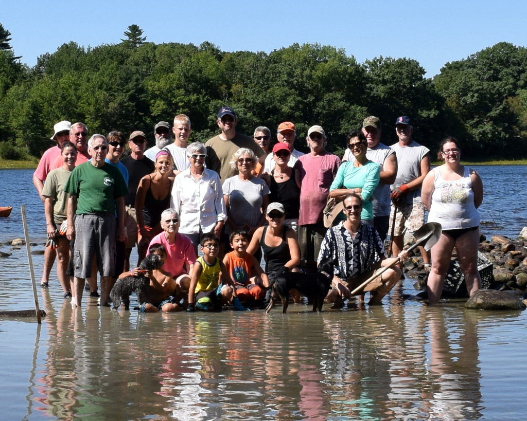
2016 Boat Launch Cleanup
As 2016 draws to a close it is a good time to reflect on what has (hasn’t) been accomplished this year. In many ways it has been a banner year for the Clary Lake Association: with 116 current members, our membership is at an all-time high and community involvement in and support of the Association and it’s activities has never been higher. Even during the height of the water level petition process in 2012 and 2013 we only had at most 70 members, and last year we had 82 members. Furthermore, our current membership is engaged and informed like never before and willing to step up and participate when the need arises (see picture above!).
 2016 was the 5th full year that we’ve been engaged in our battle to restore Clary Lake which fact in and of itself, is rather sobering. Who would have thought this problem would take so long to resolve? The fact that after all this time we’re still waiting for the Water Level Order to be enforced is simply hard to believe, and even harder to accept. Through it all the Clary Lake Association Board has steadfastly remained diligent, attentive, and responsive, and 2016 was no exception. We officially met 12 times this past year to conduct Association business, discuss strategy, and make decisions, not to mention the piles of emails sent and phone calls made. It has literally been a full time job for some of us, and I’m deeply grateful for the dedication and commitment of all our Board members. It’s a great group of people and I’m proud to count myself among them. That said, I feel like we have not done Continue reading

UPDATED AGAIN: David Hodson emailed me this afternoon to say that the final patch of open water has finally frozen over making the official Ice-In date this year December 12. Honest!
UPDATED: Clary Lake NOT fully iced over. David Hodsdon and I conferred this morning and he told me his end was fully frozen over, but he failed to notice about 1/2 an acre of open water in the cove by Jack Holland’s house. I guess there were some geese swimming in it this afternoon. Oh well. Retraction time. Stay tuned!
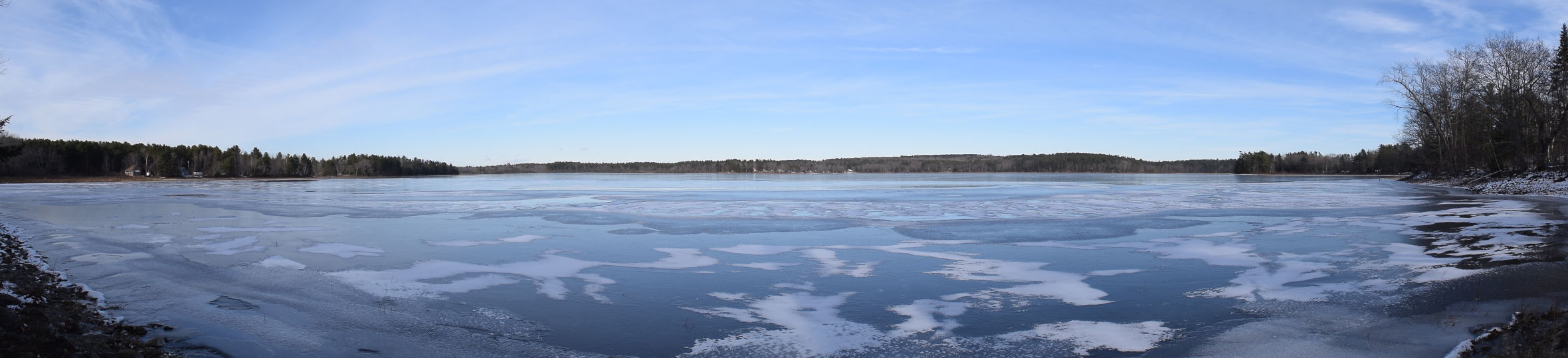
Thanks to overnight temperatures around 0° Clary Lake was completely frozen over this morning. It remains to be seen if the ice cover can survive the rain, snow and warmer temperatures forecast over the next couple of days.
 The Good Folks at Avian Haven have issued their Favorite Bird Pictures from 2016→. Check it out!
Avian Haven is a non-profit organization founded in Freedom, Maine as a wild bird rehabilitation center dedicated to the return of injured and orphaned wild birds of all species to natural roles in the wild. They have a great site and do good work.
 From the “For What It’s Worth” department, the Clary Lake dam owner was seen at the dam this morning. It appears the purpose of the visit was to close the gate, at least partway; it now appears to be about 1/2 open though it’s still not closed enough to back up water (see picture at left). He opened the gate all the way last Saturday apparently in a knee-jerk reaction to an alleged trespass on the dam by some duck hunters, which he reported to the Lincoln County Sheriff’s Department- prompting a visit from an officer. I’ve not heard any more about that incident. The gate had been completely closed since early July until he opened it last weekend.
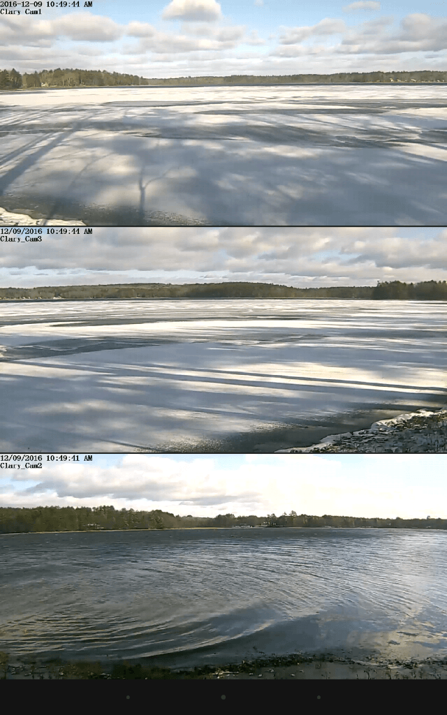 We see good skating on Clary Lake about 1 year out of 3 (if we’re lucky) and even when we do have good skating, it usually doesn’t last that long. This year is not looking like one of the good ones but it is early yet. The picture at left is a composite photo showing simultaneous views from all three Clary WebCams taken yesterday morning- it’s actually a screenshot from my tablet IP Cam Monitor app. From the lake-level views of Cams 1 and 3 (the top two images) it looks like the lake is entirely frozen over but in fact from my second-story office window I can see that the whole north half of the lake is still wide open. Also, as you can see in the bottom image, the entire east-end of the lake is open. I estimate only about 1/4 of the lake is iced over so far, and what ice we have isn’t looking very good.
 I spoke to a Lieutenant with the Lincoln County Sheriff’s Department today to see if I could find out more about the Lincoln County Deputy’s visit to the Clary Lake dam that I wrote about last Saturday. All the Lieutenant would tell me was there had been a complaint made of “criminal trespass” by Mr. Kelley and that he couldn’t say more at this time due to the ongoing investigation. I thanked him and hung up.
I have collected a little additional information about what was going on that Saturday morning by the dam, from talk around town. Apparently very early Saturday morning while it was still dark, some duck hunters parked two trucks in the field next to the fence near the dam, on property Jane Chase is caretaker of. Presumably they then launched their canoes and headed upstream to hunt. I know there were hunters up in the meadow that morning because I heard gunshots from that direction about 6:30 AM while I was having my first cup of coffee. Several people reported seeing those 2 trucks parked there later in the morning. They were long gone by the time I drove by around 1PM and saw Mr. Kelley talking to the police officer.
Did Mr. Kelley really call the police because some duck hunters parked their trucks on the neighbor’s property and headed upstream to hunt, or was something else going on? We may never know. I doubt we’ll hear much more about what happened Saturday unless there’s something in this week’s Lincoln County News. So move along folks, nothing to see here.
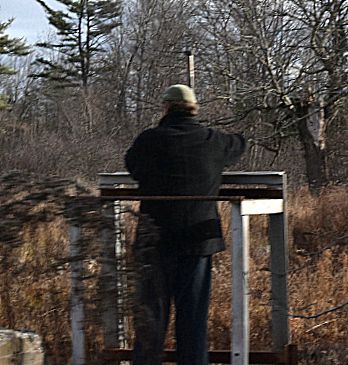
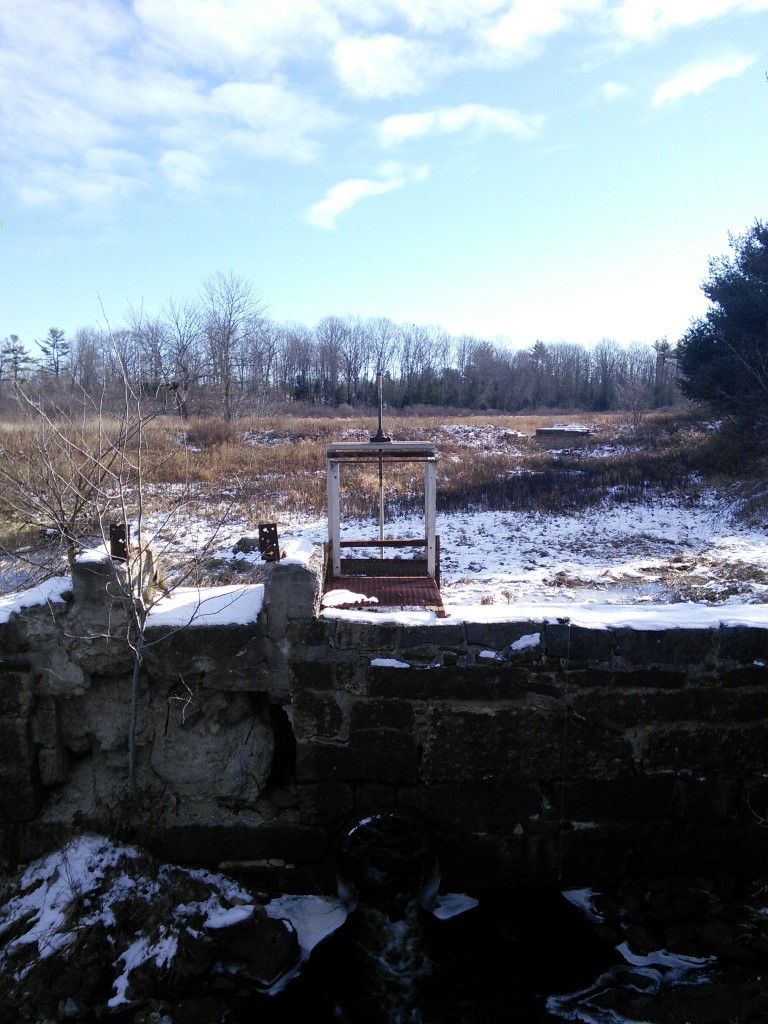
Clary Lake dam owner Paul Kelley, Jr. opening the dam’s gate today, December 3, 2016.
Today the Clary Lake dam owner was seen opening the dam’s gate (pictured at left) shortly after meeting on-site with a Lincoln County Deputy. I have no idea why Mr. Kelley summoned the police to his property or whether it had anything to do with his decision to open the gate today, but I was told by a passerby that he and the officer were seen standing on the road in front of the dam before he opened the gate and that Mr. Kelley looked “upset” and was “waving his arms” and pointing at the dam. I can’t imagine what Mr. Kelley’s problem might be.
The gate has been effectively closed since mid-summer, and I have been wondering if or when Mr. Kelley was going to open the gate this fall to provide the Minimum Flows required in the Clary Lake Water Level Order ![]() . Flows vary throughout the year: between November 16th and December 31st the Order says the gate should be opened 0.9 feet to provide 15.5 cfs (cubic feet per second) of outflows. Mr. Kelley has in fact opened the gate all the way, approximately 2.5 feet, letting out way more water than the recommended volume. Clearly, Mr. Kelley had more on his mind today than just meeting the minimum flows requirement, and he isn’t particularly interested in garnering anything like goodwill either. It seems to me Mr. Kelley could use a little of that about now.
. Flows vary throughout the year: between November 16th and December 31st the Order says the gate should be opened 0.9 feet to provide 15.5 cfs (cubic feet per second) of outflows. Mr. Kelley has in fact opened the gate all the way, approximately 2.5 feet, letting out way more water than the recommended volume. Clearly, Mr. Kelley had more on his mind today than just meeting the minimum flows requirement, and he isn’t particularly interested in garnering anything like goodwill either. It seems to me Mr. Kelley could use a little of that about now.
By early afternoon the water level in the mill pond behind the dam had fallen noticeably. I’ve revised the Water Level Charts to reflect the change in gate status.
November 2016
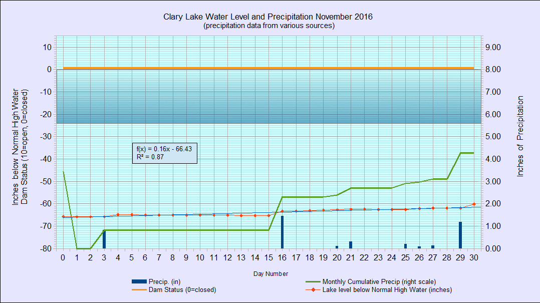
I have archived the November 2016 Water Level Chart (at left). The most notable feature of the November chart, like most of the other charts this past summer and fall, is how slow the lake level has been responding to rainfall. I am dismayed at the abysmal rate Clary Lake is filling up this fall and I’m sure a lot of you share that sentiment. Despite having received what seems like a “reasonable” amount of rain over the past two months, the lake level stubbornly refuses to rise as expected. The lake dropped to 60″ below the high water mark back on July 27th and continued from there to drop to a record low of -67.25″ on October 8th. Since then we’ve received 7.31″ of rain which has brought the lake up only a hair over 7″ to -60.17″ below the high water mark on the last day of the month. In a “normal” year that much rain would have brought the lake up the better part of 30 inches or more. Continue reading
Tonight I decided to see what rain looked like on Clary_Cam1 with the built-in infrared illumination turned on. It turned out to be rather interesting. Need a good soundtrack.
 [dropcap]There[/dropcap] has been a very nice 9″ glass Anchor Ovenware(tm) pie plate with a glass cover over at Sheepscot General, waiting for someone to come by and claim it, but nobody has. Today my wife brought it home for safe keeping. We believe it was left behind by someone who brought food to the Harvest Potluck Supper earlier this month. If it belongs to you or you know who it does belong to, give Margaret a call at 458-3143 or email her and make arrangements to pick it up.
The Maine Volunteer Lake Monitor Program (VLMP) has issued their Fall 2016 newsletter “the Water Column” and it’s available online from their website at the following link:
Fall 2016 Water Column Newsletter
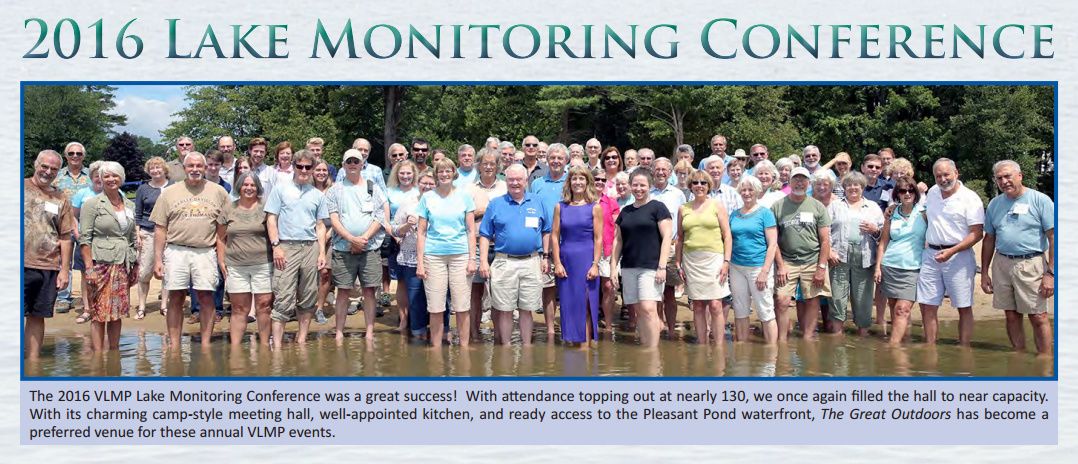
The VLMP has always done a great job with their newsletters, and this one is no exception: with 28 pages of informative articles, reports, and pictures, it is well worth taking the time to look it over. I found the article “The 2016 Drought and it’s Effect on Maine Lakes” particularly interesting.
The Clary Lake Association is long-time supporting member of the VLMP and has been contributing water quality monitoring data to the VLMP program since 1975. You’ll find the last 5 years worth of water quality data on our Clary Lake Water Monitoring Data page.
The newsletter includes a report and pictures from this summer’s 2016 Lake Monitoring Conference which David Hodsdon and I attended. Below is the group photograph taken at the conclusion of that event:

On behalf of the Clary Lake Association Board I’d like to wish you all a very Happy Thanksgiving. Enjoy family and friends, don’t overeat, don’t drink and drive, and most important, DON’T TALK POLITICS.
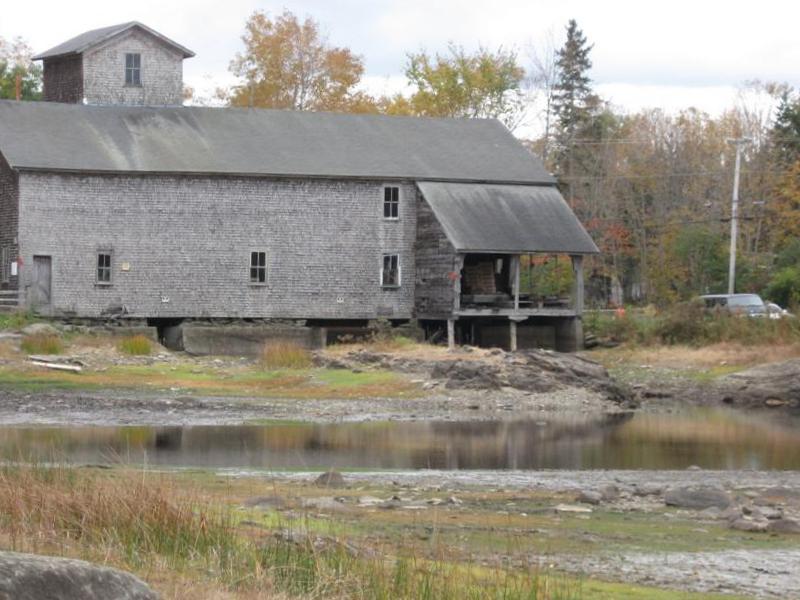 There is an article in the November 01, 2016 Central Maine Papers (Kennebec Journal, Morning Sentinel) about the Atlantic Salmon Federation (ASF) plans to play a role in the Branch Pond dam and mill site. Even after reading the article a couple of times I’m a little unclear exactly what the ASF intends to do at the site, but it appears they at the very least intend to build a fish ladder at the site and may be looking to purchase the dam and mill property outright or help with the removal and reconstruction of the mill building at another site. The dam and mill complex is currently owned by Stephen and Christine Coombs and is subject to a Department of Environmental Protection (DEP) Water Level Order issued in June of 2014. According to the article, the DEP and the Maine Emergency Management Agency (MEMA) entered into a consent agreement with the Coombs’ last spring. The ASF got involved with Branch Pond this past summer as part of their Maine Headwaters Project.
Branch Pond is a beautiful little pond at the headwaters of the West Branch of the Sheepscot River. We host a few pages for the Branch Pond Association on this website. Here’s a link to the online article:
Here’s a link to a locally archived copy should the above link fail for any reason:
 The Harvest Potluck Supper held last Saturday was a great success and a lot of fun, thanks to all the people who donated food and all the people that showed up to eat it! We all owe a huge Thank You to the Momentum Committee Chair (Erin Grimshaw) and committee members (Margaret Fergusson, Mary Gingrow-Shaw) for the work they did preparing for this wonderful event.
We had over 50 people in attendance and we made over $319 dollars (after expenses)!
Sorry for not posting this update until now, but I’ve been a little busy. Here are a few pictures I took during the supper:


 My wife and I spent the better part of last Wednesday the 16th at Lincoln County Superior Court attending 2 different hearings. I had already planned to attend the discovery hearing in the Clary Lake Water Level Order appeal proceeding (Docket No. AP-14-1 ) scheduled for 1:00 PM, then Tuesday afternoon I got a call from Bob Rubin informing me that the Judge had also scheduled a discovery hearing in the Rubin/Ayer lawsuit (Docket No. 2016 CV-002) for 9:00 AM that same day. The judge, Justice Daniel Billings, is the same for both cases. Wednesday was looking like Clary Lake day at Lincoln County Superior Court and my wife and I decided to make a day of it and attend both hearings, which we did, and we even found enough time between hearings for a nice lunch at Sarah’s.
 A little background regarding Docket No. 2016 CV-002 is in order since I haven’t written about it on this website since it was first filed: Robert Rubin and Cheryl Ayer are husband and wife, Clary Lake shore owners, Clary Lake Association members, and they are both lawyers licensed to practice in the State of Maine. Their property is on the west shore of Clary Lake. Many of you will remember Bob Rubin from the role he played during the Clary Lake Water Level Petition process, representing the Clary Lake Association pro bono as an intervener in those proceedings. Shortly after issuance of the Final Clary Lake Water Level Order on January 27, 2014, Bob Rubin retired. On January 11, 2016 Bob and Cheryl filed suit in Lincoln County Superior Court (see: “31 January 2016: Clary Lake Shore Owners Rubin & Ayer File Suit in Superior Court“). At the time Cheryl Ayer was a Board member of the Association. She subsequently resigned her Board position in April 2016 so as to avoid any appearance of a conflict of interest. Their complaint named defendants Paul Kelley, Pleasant Pond Mill LLC (PPM), Richard Smith, and Aquafortis Associates LLC (AQF). Paul Kelley and Richard Smith are defending themselves in this proceeding, they are not represented by counsel. Continue reading
 [dropcap]A[/dropcap] quick update to let everyone know what’s going on with the Clary Lake Water Level Order Appeal: back on October 4th counsel for DEP and Aquafortis Associates LLC (AQF) held a telephone conference with Justice Billings to discuss issues around the State’s requested discovery, Petitioners objections to it, and some other jurisdictional issues raised by AQF including their own requested discovery (see: 05 October 2016: Clary Lake Water Level Order Appeal Update). The Court’s conclusion at that time was that it needed “more time” to consider matters and the parties agreed to meet again towards the end of the month of October to continue their work to resolve the conflicts.
That delay stretched into 5 weeks: a conference has finally been scheduled for next Wednesday November 16th at 1PM. Presumably the issues surrounding DEP’s requested discovery and the other matters hanging fire will finally be addressed by the Court so the case can move forward. The State originally filed their request for discovery over 3 months ago, back on August 2nd. I sure hope the court can pick up the pace.
I will post a report as soon as I know something.
 Some of you may have noticed the “I’m not a robot” check box like you see below when you go to login to the site, leave a comment, or use one of our contact forms. The purpose of this is to prevent scripts (bots, or robots) from posting moronic comments or sending bogus contact emails, which are both annoying, and waste my time.
The authentication scheme is called reCaptcha and was developed by Google. You’re probably already familiar with it, in fact I’ve implemented it before on the site but it’s always been a little flakey. This is a new and improved version of reCaptcha that is supposedly easier to deal with. Using it is pretty straightforward. Just check the box that says you’re not a robot. Most of the time that’s all you have to do. If the backend authentication system believes you, you’re done. If it doesn’t believe you, it will pop up some pictures and ask you to click on the pictures that contain a storefront, or pictures that contain road signs or something like that. If you want to try a different challenge, click the reload button. I guess you can also use an audio challenge but to be honest I’ve never tried that. Try it out:
If you try to login, or submit a form or a comment without getting authenticated you’ll experience an error rather than a satisfying submission experience. A couple of people have left comments recently so I guess it’s working!
On another note, I’ve disabled caching on the site due to problems some people were having getting fresh content off the site. Other elements of site optimization are still in place and working.
 A quick reminder, the Association’s Harvest Potluck Supper/fundraiser is this Saturday, November 12th, from 4:00 PM to 7:00 PM at the Sheepscot General on Townhouse Road in Whitefield. This event is open to the general public and we hope members and non-members alike will take this opportunity to get together and share good food and good company. The cost is $7.00 for adults and $3.00 for children under 12. There will also be a raffle with details to be announced. My wife informs me that we’ve had a fantastic response to our outreach and we expect lots of food of all sorts, and a good turn out as well. Also, it is not too late to contribute to the fare, that we are still in need of a few side dishes such as salads, of whatever sort. Please contact Margaret Fergusson @ 207-458-3143; Mary Gingrow-Shaw @ 207-622-3308 with any questions or suggestions.
I’m going to send out a reminder email to all current Clary Lake Association members this evening. I realize that a number of you are no longer in Maine and will be unable to attend the Supper, but you’ll get an email just the same! Consider it a test of our Emergency Broadcast System. Please keep an eye out for it and if you don’t see it in your inbox in the next 24 hours, please check your spam folder. We’ve done extensive testing of our mail system and most mail hosts recognize our emails as Not Spam (Gmail seems to get confused on occasion). IF it ends up as spam, tell your mail program it is NOT spam!
Thanks and hope to see you at the Supper!
 When I announced that the DEP had finally established the elevation of the normal high water line of Clary Lake, I said I would be changing my water level measurement regimen to match and would post an update about those changes when they happened. Well, they happened. Nothing earth shaking to report, but there are a few things to make note of. Since I’ve been using NAVD88 elevations all along the only thing needing to change was the index value to which water levels are referenced. Telling people the water level is 148.76′ today really doesn’t impart any useful information, which is why I’ve always stated water levels in inches with respect to the top of the dam. From now on I will reference them in inches, to the normal high water line, which is very close to the top of the dam. Data collection and basic data manipulation remains the same. The Water Level Charts themselves received a few obvious edits- the left hand axis on the charts is now “Inches Below Normal High Water” instead of “Inches Below Top of Dam” and the legend has been updated to reflect this change. The difference between the two (0.22′ or 2.59″) is so small as to not be visible on the actual water level charts. Zero on the left-hand scale used to be Top of the Dam. It is now the Normal High Water Line. Continue reading