Category Archives: Uncategorized

Banner Highlights
Usually the header image/banner on the website rotates randomly. Once in a while I highlight specific banner images for a while. Today’s banner highlight is a truly ethereal sunrise taken by Kelley Doore, taken looking east from the old Morse Wemple home on North Clary Road:
01 April 2022: Unidentified Animal Sighted on Clary Lake
 I spotted this Clary Lake critter this morning when I was out checking my rain gauge. At first I thought it was a goose but the sound it made wasn’t goose-like at all. Sounded more like… I dunno. It was weird. It didn’t stick around. Fortunately I was able to find a picture of it in the webcam archive. Anyone have any idea what this is?
22 January 2022: Venus Rising
29 August 2015: Hanging out

Clary Lake shore owners Bob Rubin and his wife Cheryl Ayer hanging out on their dock on a beautiful August afternoon. For some reason, Bob doesn’t look too happy. Neither does Cheryl. I’m guessing it’s because of the lack of usable water front on their lake front property. Bob and Cheryl are both lawyers, and Bob represented the Clary Lake Association during the water level petition proceedings. Cheryl is currently a Clary Lake Association board member. The water level when this picture was taken was -64″ below the top of the dam. Photograph by George Fergusson 28 August 2015
27 November 2014: Happy Thanksgiving from the Clary Lake Association
 Happy Thanksgiving everyone 🙂 I went out this morning and thawed out the Clary Webcam which was operational, but snow-covered. I thought I’d post a picture of what the lake looks like this morning. At the top of my list of things to be grateful for today is that we still have electricity (and internet) after last night’s snow storm. This means we will be able to bake the turkey we’ve been defrosting for the past 3 days and not have to resort to sitting down to a turkey made out of hotdogs:
I don’t know about you, but I’d sit down to a bowl of Cheerios for Thanksgiving Dinner before I’d resort to a turkey made of hotdogs. Know what I mean?
Be well, stay warm, and be careful if you’re traveling today.
10 July 2013: Survey Plans of Clary Mill Property and Clary Lake Dam
 I got my hands on copies of some survey plans some time ago. I wasn’t planning on releasing them for general consumption just yet but Paul Kelley posted one as part of his FOAA booty so I figure I might as well put them all out there. First a little history: Back in 1981 there was a boundary dispute between Chester Chase and Albert and Alden Boynton. The property was surveyed by Coffin Engineering and the case went to court. As is the case with most boundary disputes that go to court, nobody but the lawyers won but the boundary lines did get established in the process. These two survey plans are sort of “before and after” plans: Continue reading
19 April 2013: Launched my boat today, which I am naming the “Peggy Ann”
This was going to be a post about my thoughts regarding Paul Kelley’s comments to Heather Parent which he submitted earlier this week, but I couldn’t think of anything I wanted to say. Maybe I will later, maybe I won’t. So right now I’ll talk about launching my boat.
Peggy Ann is the name my wife’s mother and most of her friends and relatives call her. I call her Margaret. Margaret is a wonderful name for a wife I think, but a lousy name for a boat don’t you agree?
 Today seemed like the day to do it, it was warm enough and the wind and weather was right and sounded like it wouldn’t be very good again for a while. I’ve been ready to go for the past week (last year I put in on the 21st of March). It took two of us pushing/lifting on the boat and one person standing in the back of it to get it off the trailer and into the water as there wasn’t even close to enough water to float it off. Thank goodness it’s a relatively light aluminum boat with a small motor. If it was a heavier fiberglass boat with a big motor, it would have been a lot more difficult. The State designed the ramp to require a minimum of 2.3′ of water over the foot of it but today there was only about 1.7″ of water over the end of it. I didn’t take any pictures but it must have looked a lot like this one at left though today the water was about a foot higher than in the picture. Now that it’s boating season again I will start including the “water over the foot of the ramp” data to the water level chart.
Also planning on putting the Hobie Cat in the lake this year even though low water will make it risky to sail (it’s hairy enough as it is to sail it without having to worry about hitting rocks at 20 knots). But I figure I know where the ledges, shoals, and rocks are and I’m not going to let Paul Kelley and his low water regime rob me of another summer of sailing. We’ll be putting it in sometime in mid to late May, as soon as the water warms up a bit more and I can get a mooring set.
13 April 2013: Low Water having an impact on wetland vegetation
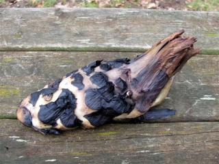
Imagine my surprise the other day when I went down to the lake to measure the water level and saw what looked like a foot floating in the water… well it turned out not to be a foot thank goodness. It is some kind of water lily rhizome, most likely that of the Yellow Pond Lily (Nuphar Lutea) though I’ve never seen
 one that looks quite like this; then again, the other Yellow Pond Lily rhizomes I’ve seen were more mature, much larger and long, several feet or more in length. Perhaps this is what they look like when they’re young and just getting a foot-hold (pun intended) in the marsh. I’ll bet that’s it. Here’s a picture of the underside of the root.
It’s about the size of a child’s foot.
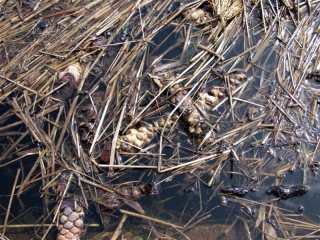
There have been quite a few of the Yellow Pond Lily rhizomes getting washing up on the shore, more evidence of the impact the low water conditions are having on the sensitive wetland habitat around Clary Lake. The low water conditions exposes the roots to the elements and ice and rain erodes the soil holding them in place. Then they wash into the stream and float away. I’ve posted pictures here before of these rhizomes. Here’s a picture of some that floated down stream to collect at the dam. I’m half inclined to see if these can be collected and replanted. Seriously.


