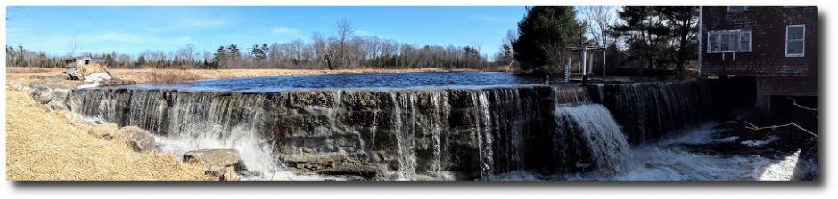
Category Archives: News

News from around the lake.

24 February 2015: Chilly morning on Clary Lake

Schedule_20150224-064203.jpgIt was -27° this morning on Clary Lake, according to 3 different thermometers. Now that’s bracing! If you feel like it’s been a cold month, you’re right. According to the National Weather Service at Gray, Maine, this has been the coldest February on record with an average temperature of somewhere around 13° (record keeping began in 1940). Sure seems like the temperature has been below 0° every morning since sometime in January.

10 January 2015: Comet Lovejoy is well placed for viewing

Comet Lovejoy is well placed for convenient, early evening viewing. It’s bright enough to be visible to the naked eye but I recommend at least binoculars to get a good view of it. The finder chart below shows the comet’s location on the evening of January 10th. If you can find Orion, you can find the comet. It’s moving fairly rapidly in a northerly direction and getting higher in the sky all the time. On the 17th, it will be just south of the Pleiades.

Here’s a Sky & Telescope article with finder charts and photographs.


02 January 2015: Extraordinary skating on Clary Lake, and a word of caution

IMG_4437 (Custom)The ice skating on Clary Lake has been extraordinary this year, and a good many people have taken advantage of the fabulous conditions. This afternoon I was out skating and encountered 4 people from Waldoboro (at left) who’d heard about the excellent skating conditions on Clary and came by to see for themselves. They were suitably impressed. Unfortunately the snow, sleet, and freezing rain storm coming in tonight will likely put an end to skating this winter. Here’s a video I shot this afternoon.

IMG_4421 (Custom)A word of caution: despite the low temperatures, there is still a considerable amount of open water out in the middle of the lake, (see video above) and a few open or mostly open leads around the shore where you wouldn’t expect to see them. This condition is due to a combination of the relatively high water level (2′ below the top of the dam) and a strong current resulting from the dam’s gate being wide open (the lake level is dropping about 1″ per day now). The current flows in a generally straight line from the inlet by the State boat launch passing close by the point at the end of the Duncan Road, to the outlet channel at the northwest end of the lake. The channel itself is ice free as well. The picture at left was taken New Years Day and the open area has gotten considerably larger since then.

This condition has occurred several times in the past few years. These open areas will probably fill with slush from the coming storm and skim over without getting really solid. Snowmobilers and skiers beware: if you don’t know where the safe ice is, you’d best stay close to shore or off the lake altogether.

xDSC_5451I’ve also posted a few pictures in the Winter 2015 photo album that Tony Marple sent me yesterday, including this one at left that almost could have been taken on a calm summer day. The clouds reflected on the ice show just how smooth it really is. Thank you Tony.

2014 Water Level Charts Archived

And so we come to the end of another month, and for that matter, another year. I’ve just posted the 2014 chart (below) in the 2014 Water Level Charts album. This makes the third full year that I’ve been recording Clary Lake water levels. You’ll notice that last winter I stopped making water level measurements in early February and didn’t resume until April

1st due to cold weather, deep snow, and (for a while) ill health. I’ll keep measurements up as long as practical this winter but I imagine when winter really sets in that I’ll take a break and resume when weather permits.

12 waterlevelchart_December2014The December 2014 chart (at left) is interesting. The rainfall we received back on the 9th of the month and over the next few days, though only 1.78″ in total was enough to bring the lake level up fully 16″ and to within an inch of 2 feet below the top of the dam for a runoff multiplier of 9 x (1 inch of rain = 9 inch rise) due to partly melting snow but mostly just because the ground was frozen. In other words, little if any rainfall soaked into the ground. It all ran off (the runoff multiplier during summer months is generally more like 4 x). Subsequent additional rainfall brought the lake level to 22″ below the top of the dam, right about where it would be this time of year if the Water Level Order being adhered to.

I’d also like to take this opportunity to wish everyone a safe and happy New Year’s Eve and a happy and productive New Year. I sincerely hope that 2015 sees the Clary Lake water level order implemented, the lake level restored, and a satisfactory resolution of all the issues surrounding the Clary Lake dam, for all parties. The Clary Lake Association is diligently working to bring these things about. With your help, we will succeed.

November 2014 water level chart archived

11 waterlevelchart_November2014

November 2014

And so we come to the end of another month. You’ll find the November 2014 water level chart in the 2014 Water Level Charts Album. The lake level stayed in a fairly tight range for the entire month, right around -50″ below the top of the dam, give or take a few inches. It got as high as -48″ at one point and low as -52″ below the top of the dam. With only 2.66″ of precipitation for the month (average is 4.36″) you’d have expected the lake level to have fallen more. However, the ground is fairly well saturated from heavy October rainfall so most of the precipitation we received ran off into the lake. Also, the lake only falls about 1/2 inch per day when it’s at this level so it doesn’t take much precipitation to keep the lake level constant.

And that’s the way it looks from here.

30 November 2014: Clary Lake iced-in

Clary cam - 2014-11-29 15.44.47Clary Lake was completely frozen over the morning of November 29th and well-below freezing temperatures all day undoubtedly added to the thickness of the ice coating. A lite dusting of snow coated some pre-existing ice the night before, as the cam picture at left shows. I was going to post this yesterday but David Hodsdon thought we should wait to see if the ice survives today’s temperatures at or above 40°. If so I guess we can consider it iced-in for the duration. David Hodsdon has been keeping track of Clary ice-in and ice-out dates for the past dozen or so years.

It’s too soon to tell if we’re going to get ice worth skating on. Only about 1 year out of 3 does the lake freeze over smoothly enough and stay snow free long enough to provide for good skating. And when the conditions are right for skating you need to get out and enjoy it because it won’t last long. Here’s a video I took back in December 2010 when conditions were just about as good as they get. It features me on camera and my wife Margaret pushing a chair (which is how most of us older folks ought to be skating anyways):

 I’ll post a few more when I get a chance.

19 November 2014: A little ice around the edge of the lake

campic_19November2014

Skim ice!

For the first time this fall that I’m aware of, the lake has a little skim ice around the edges this morning. I hadn’t thought the water had cooled off enough to freeze because I was seeing lake-effect warming just the other day. I guess it is ready to freeze up! I remember years ago ice skating over Thanksgiving. I wonder if I’ll get to do that this year? According to our ice-in, ice-out records which go back to 2001, The earliest the lake has fully frozen over was back in 2002, on November 29th though last year it froze over on November 3oth.

16 November 2014: Clary Lake Association eligible for donations through AmazonSmile

The Clary Lake Association is happy to announce that they are now eligible to receive donations at no cost to you in the form of a small percentage of your purchases on AmazonSmile. For those of you who have never heard of AmazonSmile (I hadn’t until a few days ago), it’s simply another way to shop at Amazon.com with the difference that anything you buy on Amazon.com you can buy on AmazonSmile and Amazon will donate 0.5% of the purchase price to the charity of your choice! We of course would hope that you select the Clary Lake Association as your preferred charity, but you are free to select any charity you wish. All you need is an Amazon.com account.

You’ll notice a new AmazonSmile banner over on the sidebar, just to the right (under What’s New”) just like the image at the top of this post. When you click on that banner image you’ll be directed to smile.amazon.com pre-configured with the Clary Lake Association’s ID so you can just start shopping. You can also share that link with your friends and colleagues so they too can contribute to the Association:

http://smile.amazon.com/ch/01-0495730

Now, 0.5% doesn’t amount to a lot of money on any given sale (only 50 cents on a $100 purchase), and our user base at present is rather small but if you use it, and you ask your family and friends to use it, over time, it can add up to real money. I have the distinction of being the first person to use AmazonSmile to contribute to the Clary Lake Association; earlier today I ordered a linquini attachment for my Marcato Atlas pasta machine, something I’ve been wanting for a long time. It cost $39.95 and the sale resulted in a $0.19 donation to the Association 🙂

Remember, it costs you nothing to contribute to the Clary Lake Association through AmazonSmile.

For more information about AmazonSmile check out their About AmazonSmile page.

11 November 2014: DEP issues Lake Elevation Survey

The Department of Environmental Protection has released an Elevation Survey for Clary Lake dated October 28th conducted by CES, Inc. , a consulting engineering and surveying firm with offices in various cities around Maine. The field work for the survey was conducted in the vicinity of the State boat launch on October 14th and refers to engineering work completed back in 2002 during the construction of the boat launch. The elevations on the survey are referenced to the NAVD88 elevation datum and are based on GPS measurements.

Special Condition 4 of the Clary Lake water level order required the dam owner to retain the services of a licensed professional land surveyor to establish the historical normal high water line of Clary lake. This survey was to have been completed and submitted to the Department by June 2nd of this year. Since the dam owner failed to complete the work as required, the Department of Environmental Protection has done so. This is a welcome development.

The survey concludes that the crest of the dam has an elevation of 151.17′ (NAVD88) and that the highest observed stain line on a rock in the vicinity of the boat launch has an elevation of 151.2′ (NAVD88). Thus, the survey has concluded that the historical normal high water line of Clary Lake is the same elevation as the top of the dam.

12 October 2014: Clary Lake Webcam back in operation

The Clary Lake webcam is back in operation, at least for the time being. We’ll see how it fairs when really cold, inclement weather gets here- I may have to move it indoors but for now it’s up and running. It’s not an optimal setup by any means but the picture quality is a whole lot better than the old webcam and the view is much improved too: wider, higher resolution, less trees, more lake. In fact, the image is so wide it won’t fit on the page completely without cropping. I’ve put a link to the actual image on the webcam page so you can download the full-width original.

Unlike the old webcam, this is a standalone wireless camera and doesn’t rely on a resource-hog of a program to compete with me for CPU cycles, monitor the camera, take the pictures, and upload them to the web server- all that functionality is built into the camera. This will make it a whole lot more reliable. I can also remotely mess around with the camera, changing the picture size and where it’s pointing, and zoom in and out.

A planned future enhancement: installing a staff gauge in the field of view so you can remotely view the current lake water level. That would probably not work well in the winter when the lake is frozen.

04 October 2014: Who says the State boat launch is unusable?

IMG_4337 (Custom)Jack Holland called me earlier today and told me to get over to the boat launch and bring a camera. I didn’t stop to ask questions, I just dashed off. Well, the scene I encountered when I arrived there a few minutes later defied comprehension (see picture upper left). Nonplussed, I decided to just shoot first and ask questions later (you’ll find them in the new Fall 2014 gallery). I also decided to shoot a couple of videos. The first one shows them hauling the Cat loader out of the muck:

I was surprised and impressed those 2 trucks managed to drag that loader out, I’m pretty sure it weighed more than both trucks put together. Then with the loader out of the way, they were able to address the pickup truck problem:

I guess this situation would be funny if it weren’t so tragic. Backing your truck into the lake to get your boat because there isn’t enough water at the end of the ramp was not a great idea, getting stuck was virtually guaranteed. Getting the Cat loader stuck was inevitable once the (bad) decision was made to drive that into the lake to pull out the truck. Then they called dad.

These kids were fortunate really, nobody injured, nothing lost but face. Oh. And a broken drive shaft. And a tow rope. They stirred up a plume of clay sediment (visible in the above video) that will take a while to settle out and they’ve left some ruts in the lake bottom that will be there for years to come, but to put things in perspective, really, the environmental impact of their silly escapade is inconsequential in comparison to that being visited on Clary Lake by the dam owner himself, and through their inaction, the Department of Environmental Protection. Kids will be kids. While it is easy to be critical of their behavior, I can remember doing some pretty stupid things myself when I was young. Nothing like this of course.

29 September 2014: Irate Lake Shore Owner sends letter to DEP

I received the following email today sent by Clary Lake shore owner Jean McWilliams to Beth Callahan of the Department of Environmental Protection. Jean has every reason to be upset. We all do. One does have to wonder what the DEP is waiting for: the lake can’t get much lower.


September 29, 2014

Dear Ms. Callahan:

I am writing as a waterfront property owner on Clary Lake. I want to share my prospective as a resident on Clary Lake who has enjoyed this (previously) unspoiled lake for over 20 years. 

Jean McWilliams' water lineThis past weekend was warm and glorious and I planned to spend the weekend at our camp. Imagine my surprise when upon starting the water pump, there was no water. The first enclosed picture shows why;  the water line was fully out of the water. I have already extended the line once since the near draining of the lake. Apparently my family won’t be able to use the camp for the rest of the season, thanks to Paul Kelley’s actions.

Jack Holland's boatI’ve also attached a picture of my neighbor’s boat, high and dry as you can see. I am now 66 years old and have always planned to sell the camp in order to retire. As you can well imagine, property on Clary Lake is not exactly in demand.  So much for retirement, and again, thanks to Mr. Kelley. I am simply stunned that this situation has continued for over 3 years. The DEP has issued a water level order.  Mr. Kelley has ignored it.  He clearly does not care about the environmental, economic and recreational damage his actions have caused. I strongly urge you to enforce the water level order and insist that Mr. Kelley follow the law.  The blatant actions of this man are unacceptable and I ask that you enforce any and all regulations broken by Kelley.

Sincerely,

Jean McWilliams


Whitefield Selectman’s Meeting Agenda for Tuesday 23 September 2014


Below is a tentative agenda for Tuesday’s meeting:

Town of Whitefield Selectmen’s Agenda
September 23, 2014

Item Time Agenda Item
6:00 pm Call meeting to order
Sign Minutes 9/9/14
6:05 pm Sign Warrants Accounts Payable/Payroll
6:15 pm Fuel bids
6:20 pm Roadside Brush cutting
6:30 pm Paul Kelley RE: Building transfer
7:00 pm Fred Duncan RE: Senott Rd./DEP Letter/Tax issue
7:15 pm Discussion

a. Inter local community cooperation
b. Next Week’s Agenda
c. Other
8:00 pm Adjournment


10 September 2014: Updated Bathymetric Chart available

Clary_Lake_Depth_Map_with_aerial_SMALLI’ve updated the recently released bathymetric chart with new contours using some additional data in the vicinity of the ledges at the northwest end of the lake and a few other rocks. The revised contour map now clearly shows both those ledges and the rock currently marked by a white buoy in the vicinity of the Whitefield/Jefferson town line near the north shore. Also, the 148′ and 146′ contours have been replaced with 1′ depth contours making this version of the chart more accurate in depicting the shallow water around the shoreline. I will, as time permits, further refine the underlying data.

If you’re not seeing version 0.2 dated 09/10/2014 (check lower left hand corner) try clearing your browser’s image cache.

Several people asked about getting a contour map superimposed on an aerial photograph. No problem! There are now two images available, a large scale one and a smaller more manageable image (click on the thumbnail at upper left). They’re also available on the Maps, Charts, and Graphs page. You’ll also find a .KMZ file there which you can load into Google Earth.

06 September 2014: New Clary Lake contour map finally available

Clary_Lake_Depth_MapI have finally gotten around to generating a contour map of Clary Lake using data collected by the Department of Environmental Protection during their September 2012 bathymetric survey. In addition to the high resolution image pictured at left there’s a smaller version available, and a 24″x36″ PDF which is quite large but which can be viewed or printed out at about any scale you wish. Feel free to download them, you’ll find them and the other files pertaining to the original bathymetric survey over on the Maps, Charts, and Graphs gallery. Each image has a link in the description field to the full-sized image.

The data set consists of 3,265 points with each point defining a 3-dimensional location on the face of the earth (i.e., the latitude, longitude, and water depth below the top of the dam). The depth was measured with a depth meter and each depth measurement was paired with the latitude and longitude of the point obtained via GPS receiver. The data in the form of a spread sheet was supplied to us back in April 2013 along with a colorized bathymetric map of the lake generated from the data. This map was a marked improvement over the original depth map of Clary Lake, prepared by the Department of Inland Fisheries & Wildlife back in late 1940s, but it lacks some real utility because it doesn’t show you what the bottom of the lake actually looks like- where the hills are, where the holes are, what the depth is at any given spot. According to the original depth map, the deepest spot in Clary Lake was only 23′ whereas we now know that the deepest spot is actually 29′ below the top of the dam. Continue reading

Maine VLMP hosting a Watershed Survey Workshop

id-map-of-sitesEvery year in early September the Maine VLMP holds a Watershed Survey Workshop in conjunction with the Department of Environmental Protection. I attended one put on by the Damariscotta Lake Watershed Association this past spring and found it both educational and fun. Anyone planning on helping out with updating the Clary Lake Association’s 2001 Watershed Survey (tentatively scheduled for next spring) would benefit greatly from attending this workshop. Contact me if you have any questions or would like more information.


Watershed Survey Workshops

2014 Watershed Survey Training Workshop

How to Identify, Monitor and Mitigate Ways in Which Watershed Land Use Influences Lake Water Quality

Fri. September 12, 10AM to 3PM – VLMP Lakes Center, Auburn

WatershedSurveyPicNewBkgdVirtually all of the natural characteristics of a lake are influenced by the land area, or watershed, that drains to the lake. But human activities that alter the natural protective features of lake watersheds can result in significant degradation of water quality and aquatic habitat over time, unless conservation measures are undertaken to protect the lake. This workshop will cover basic information about the relationship between lakes and their watersheds, common threats to lake water quality from watershed development, and how to identify and resolve problems through the watershed survey process. We will begin with an inside discussion, followed by a field trip to a nearby lake watershed.Please bring a brown bag lunch. 

Pre-registration is required. To register please contact the VLMP office at 207-783-7733 orvlmp@mainevlmp.org.

18 August 2014: Whitefield Selectmen write the AAG

The Whitefield Selectmen have sent a letter to Assistant Attorney General Thomas Harnett, the person handling the Clary Lake water level order and its pending appeal filed by Paul Kelley in Lincoln County Superior Court. The letter urges the AAG to expedite the current mediation process and enforce any violations of the water level order that may be found to exist.  It was sent by email to the Service List. It has also just been posted on the Town of Whitefield’s Facebook page. It’s short and sweet so I’ll copy here in its entirety:


Thomas Harnett
Assistant Attorney General
Department of the Attorney General
State House Station 6
Augusta, Maine 04333-006

Dear Mr. Harnett:

The Town of Whitefield would like to convey to you its continuing concern about the
present state of water levels in Clary Lake. Since 2011, the lake level has been lowered and resulted in continuing and significant impacts to the environment and our community. Without going into details as they are well documented in the record, the low water level has adversely affected Clary Lake’s suitability for recreation, navigation and as a habitant for fish and other water dependent species. While the dam has been described by the owner as “breached”, it is in fact just damaged and reparable.

The Town is asking that your office actively use all means at its disposal to resolve
pending issues in order to restore Clary Lake water level to that which existed prior to 2011. In particular, your assistance in the expediting the current mediation process and enforcing any violations of the DEP’s water level order that may be found to exist would be appropriate and appreciated.

Thank you for your consideration and assistance.

Sincerely,

Aaron Miller
Administrative Assistant to the Select Board
Town of Whitefield
cc: Service List


“Damaged and reparable.” Nice they got that bit in there.

The Selectmen voted to send a letter last week at their regularly scheduled Select Board meeting. That meeting was covered by the Lincoln County News (see: Whitefield Selectmen to write State officials about Clary Lake). I greatly appreciate the Whitefield Selectmen taking this assertive step.

Here’s a link to the actual document:

16 August 2014: Algae bloom not getting any better

IMG_20140816_090956The algae bloom that appeared a few weeks ago (see 01 August 2014: Yet another algae bloom in progress) hasn’t gotten any worse, but it certainly hasn’t gotten any better either. Today’s secchi disk reading of 2.00 meters (6.56′) shows that the water transparency has only marginally improved from 2 weeks ago when it was 1.82 meters (5.97′). The green scum you’re seeing around the edges of the lake are the dead and decaying carcasses of the cyanobacteria (blue-green algae) that are responsible for the bloom. I took the picture at left this morning. Not very appealing.

It remains to be seen whether lake transparency slowly begins to improve or deteriorates further. I suspect, given the time of year and the low water conditions that we’re likely to see the bloom get worse as fall approaches. Both the Volunteer Lake Monitor Program folks and the Department of Environmental Protection are aware of the situation though it certainly wouldn’t hurt for a few more people to contact the DEP’s Division of Environmental Assessment and let them know what is happening. Here’s a link to their web page with instructions on how to report an algal bloom:

13 August 2014 Lincoln County News: Whitefield Selectmen to write State Officials About Clary Lake

George Fergusson, left, of the Clary Lake Association and Tom Hayes, Whitefield’s assessors’ agent speak to the Whitefield Board of Selectmen Aug. 12. (Kathy Onorato photo)

At their regularly scheduled meeting last Tuesday night, Whitefield Selectmen voted to write a letter to State officials expressing concern over Paul Kelley’s obstinate refusal to implement the Clary Lake water level order, according to an article in this week’s Lincoln County News by Kathy Onorato. In a brief telephone interview on Wednesday, Kelley complained about not having been notified that his company, Pleasant Pond Mill LLC, was going to be discussed at the meeting. For the record, I was at that meeting and the name “Pleasant Pond Mill LLC” was not mentioned once that I can recall though Mr. Kelley’s name was used numerous times. Also for the record, the Selectmen’s agenda was published on the Town’s facebook page on Monday. Apparently Mr. Kelley is not following that page:

Continue reading