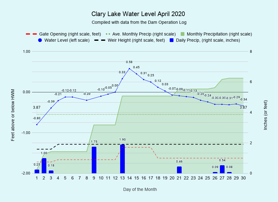
I have archived the April 2020 Water Level Chart (at left). The most notable thing about April (aside from the cold weather!) was the excessive rainfall we received which resulted in a short but intense period of extreme high water. Two back-to-back storms on the 9th and the 13th dropped a total of 3.65 inches of precipitation. In addition to a good charge of rain, the first storm also included about 8 inches of very heavy wet snow which completely melted during the second weather event, which was all rain. The resulting runoff from both storms caused the lake level to rise quickly, cresting at 151.75 feet or fully 0.58 feet above the High Water Mark, by far the highest we’ve seen the lake in a long time. The last time I saw more water going over the dam was during the Patriot’s Day storm back in 2007. According to our Dam Operation Log total outflows peaked around 230 cubic feet per second. We hurriedly opened the gate all the way the day before the storm and left it open for 5 days to help drain off some water, and the lake level quickly returned to where we want it this time of year: at or very close to the top of the dam.
We received a total of 6.25 inches of precipitation in April, fully 2.38 inches more than the monthly average of 3.87 inches. This brings us to 16.14 inches for the year to date or 2.70 inches more than the average of 13.44 inches. We’ll see if this trend keeps up in May.
Here are a few pictures from the April 14th high water event:


