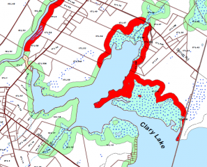
I kinda wish I’d thought to include this section of the Whitefield Shoreland Zoning Map produced by the Sheepscot Valley Conservation Association in my Comments to DEP on the bathymetric survey. It clearly shows as all the wetlands that the State left off their plan. The legend refers to those greenish blue areas with the blue dots as “Wetlands in Shoreland Zone (NWI)” which I assume refers to the National Wetlands Inventory, which I cited (numerous time) in my comments. So I guess it’s covered. On the other side of the coin, you can see why Butch Duncan is a little irritated: that bright red boundary along his property is a Resource Protection Zone. Of course, that same Resource Protection Zone bounds all of Howard Nickerson’s property, all of Sue McKeen’s property and her daughter’s property, all of the Mathews, Shorey, and Weeks properties, and a little bit of the next lot south (Roever?) and we don’t hear them grousing about the water level being too high and arguing for the removal of the dam.
Clary Lake Association
Preserving and Protecting Clary Lake

